October cycle tour map

October cycle tour map

Pages

Sunday, February 28, 2010

Camperdown to Colac


Camperdown - Colac (via back roads) = 64km
Cummulative total = 1039km
Yipeeeee we passed the 1000km mark today and we didn't even realise!
We had a glorious rest day yesterday ... did nothing ... I didn't even want to attempt to go back down that hill for I knew that I would have to face getting back up it! (so I sent Neil down to get the food!!!). We watch a few episodes of 'Madmen', a little walking and reading.
We woke this morning to grey skies and a really freezing cold wind. I thought that later on it would warm up a bit but I ended up cycling most of the way in my merino (that is how cold it was - not even cycling could make me take my merino off!)
Neil decided that we would take a different way out of Camperdown today so we rode out of town on the Princes hwy for a few kms and then rejoined the road to Lake Purrumbete. Now of course Neil didn't look up any names of the roads or anything like that so basically I think he just guessed that the roads would connect up to each! At one point I thought we were lost as I didn't recognise anything around us not even this freaky looking tree/fence line that I thought was great to look at!

The tree line looks like it is having a 'bad hair day'. While I had stopped I thought I would take a photo of the general direction that I thought Colac was in.

Somewhere out there is Colac and I think this is what Neil does when he decides which roads to take ... basically he just follows the sun as a guide even when there is no sun!
Eventually we found the road that looked familiar and we took a break just after Lake Purrumbete. We pulled over to a paddock of young cattle and for some strange reason we both start mooing and making noises trying to encourage the cattle (I don't know why we do that we do it all the time as we cycle, I suppose it is to get a reaction out of the animals!). Anyway they are there mooing back and Kouta is beginning to get excited and then next thing you know they are all beginning to move towards us mooing and bellowing, so we are both still encouraging the cattle and I couldn't help but get this cute photo of Kouta just sitting there watching them and I begin to wonder just what is our little dog thinking.

Is he thinking yummmmm dinner? and I also think about what the cattle might be thinking ... are they thinking ... mmmmmm he is a funny looking cow!!! Man rereading this I think I have had to much sun!
We start out again before we cool down too much and we have been on this road before and I am not sure but I think Kouta either recognised everything or he needed to go for a dump because he was just throwing himself around in the trailer. We took him out 3 times to see if he would unload himself and 3 times he just looked at us stupidly. At one point we made him walk while we rode and he surprised me as he seemed to really enjoy trotting alongside of us!

He trots along around 5km per hour so it would take us nearly 13 hours to get to Colac at his rate! After a few hundred odd meters we put him back in the trailer.
It was a mixed bag of cycling today we either had a severe crosswind or a head wind and after Bungador it was either a severe crosswind or tail wind. Just after Swan Marsh we took an unsealed road that follows the railway line but that was too sandy for us and it was hard to keep the bike under control and with a severe cross wind it was almost impossible to keep out of the soft part of the road. So as soon as we could we rejoined the sealed road and had to take the Princes hwy for the last 10km into Colac. As much as I hate riding on the major highways, today just confirmed that I think Australia needs a major bike highway!!! It was very busy and luckily we had a shoulder that was quite reasonable to ride in. But the center line has those noisy corrugations that are designed to wake drivers up if they accidently cross them ... well as lovely as the cars are when overtaking us they would cross this central line in order to give us plenty of room (not that we needed it!) and I tell you, I don't know what they sound like from the inside of a car, but on the outside when you are on a bike they are the most annoying and noisiest thing you can hear when cycling - it is just like someone running their fingernails down a blackboard!
Once we turned into the street Kouta realised where he was and was very excited about it! Rest day here tomorrow and then the 3 day cycle to Werribee and home. See Sharon we will be home 1 day earlier than expected so no need to panic - we will be at the airport!

Friday, February 26, 2010

Mortlake to Camperdown


Mortlake - Camperdown = 41km
Cummulative total = 975km
Either Neil and I are getting really old or we are just 'fatigued' at the moment! After putting our absolute faith in the weather forecast we decided to make a run (more like 'cycle') for it to Camperdown knowing that the camp ground wouldn't be as crowded and had kitchen facilities - well one thing we learnt and that is ... don't believe the weather forecast! We woke up nice and early and there was no wind to speak off (which is good!) and we had brekky over at the table near the lake so we could watch the sunrise.

You can't quite see the sun rising (but trust me it is!). While enjoying our breakfast the weather comes on the radio and the cheerful announcer mentions that the wind has now turned around and is coming from the North. We are all smiles and can't wait to start riding with a tail wind ... well after leaving the campground at 8.15am by 8.16am we weren't smiling any longer ... the wind was still coming from the south east and we were riding into it!
Damn I thought should we still stay or trust that it will swing around to the North? Ah decisions, decisions! So we kept on cycling. Our legs felt like lead after the previous 3 days of hard cycling and after the first hour they finally began to loosen up and the lactic acid began to disappear, still not alot of power in the legs but enough to persevere with the cycling.
It was a lovely quiet road and we have taken this route before and I think even the cattle recognised us as they didn't bat an eyelid when we passed as sometimes cattle go beserk when they see us and panic and run! (kouta loves it when they do that!).
Believe it or not the actual wind did start to turn towards a Northerly but in saying that so did the temperature! So with a little wind behind us we picked up speed and cruised into Camperdown at around 11am. We decided to go to Safeway which is at the opposite end of the town to pick up supplies and then we had to cycle the 'big' hill up to the campground which is situated right under the telephone tower. Now that hill is not steep just loooooooong and never ending!
By now the temperature is warm and we sit down for a cuppa and toast (raisin toast mmmmm!). We will stay here tomorrow to recuperate (spelling?). This campground at Camperdown is probably one of the better campgrounds for us as they have a huge kitchen with tables and bbqs, fridge, kettle and toaster so it is 'easy' camping for us. The only down side is the kitchen is made of corrugated iron and so on a hot day like today it is stifling in there so I have come to the botanical gardens which has a shelter with tables, bbq and power point to do this blog.

The above is a photo of where I am right now, it has a lovely cool breeze under these huge trees, top spot and it is right next to the campground and NO ONE is around! gotta love these community bbq areas - and alot of towns have them!
Also since we are on top of the hill the view is spectacular.
Not too sure what we will be doing on our rest day - we might try and sleep in but unfortunately I get too hungry to sleep in!

Thursday, February 25, 2010

Penshurst to Mortlake


Penshurst - Mortlake = 58km
Cummulative total = 934km
Unfortunately there are no photos today as I forgot to put the memory card back into Neils camera and again it has all gone onto the cameras' internal memory which we can't retrieve until we are back in Melbourne as we didn't bring the cord! Silly me!
Anyway there wasn't alot of looking around today - due to the solid headwind this morning all I really saw was the tar on the road (fascinating!!!) as I had my head tucked in and just pedalled!
It was no use getting up early this morning as the wind didn't cease at night and just kept blowing and blowing all night and continued right through this morning. But we did endeavour to get up marginally early (6.30am) and because of the wind the temperature was rather 'chully'
and I think it was around 7 degrees last night (don't quote me on that!). We have noticed that the mornings are getting cooler and have had to dig out the merino thermals to cope!
We departed Penshurst around 8,30am and took the Hamilton Highway and we noticed that there was hardly any traffic on it. It was great to Caramut, despite the headwind, we travelled quite well. There was even a few dips and bumps to get through but they provided a welcome relief from the wind. From Caramut to Hexam is another story! by now the traffic had picked up but even still there wasn't alot especially trucks I suppose they were on the other highways! Anyway the road became quite flat and open and so we had no protection from the wind except for when a farmer had kept their cyprus trees which buffer the wind (and believe me you do notice the difference when they are shielding you from the wind!).
From Hexam to Mortlake the road turned almost South and that made the going easy as the wind was coming from the East so it was more a cross wind and by lunchtime it had begun to die down (at least it felt like that!) but every now and then you would get a strong gust come through and that would stop you almost dead!
So we arrived here at Mortlake around 1.30pm and the campground (council one again) is rather full as they are here working on the new power station so we were intending to have a rest day here tomorrow but we may not and push on to Camperdown as believe it or not tomorrow could be a tailwind for us as there is suppose to be a north westerly wind so who knows - we shall decide tomorrow.
There is not many facilities in this campground so I am here by Tea Tree Lake under a new shelter with bbq and tables (and a power point) and I am about 30m from the tent and I am overlooking the lake so at least that is a plus with this campground ... until all the other campers come home and use the bbq! I must admit when Neil and I passed through Mortlake late November last year we thought it looked like a nice place so we decided to stop here this time and while having our cuppa this afternoon I think we were both disappointed with it, not too sure what we are disappointed with but we feel that Mortlake is not living up to our expectations (not that we have high expectations or anything!).
If we go to Camperdown tomorrow we know the caravan park is good (as we have stayed there before) and we will have a rest day there as it would be our 4th day riding tomorrow.

Wednesday, February 24, 2010

Wannon falls to Penshurst


Wannon Falls - Penshurst = 54km
Cummulative total = 876km

We had a late start today as we (namely Neil) slept in!
Last night before it got dark we went back down the hill to see Wannon Falls and assumed at this time of the year there would be now water falling and I was right. Then I began to wonder just when was the last time this place actually saw water falling from the falls? I thin Victoria needs to rethink how it names places - why name it Wannon Falls when most of the time there is not water falling? Another example of this is we passed 2 lakes today neither with water and it looked like there hadn't been water in the lakes for some time! So to avoid some disheartened tourists rocking up and expecting water to fall at falls and water to be in lakes maybe they shoud rename tourist spots to avoid tourist disappointment!
In saying that, the area around the falls is lovely and there is water in the Wannon River but it is not flowing.

When we took this photo Kouta thought as he was being picked up that he was going to be put in the river for a wash!
Wannon Falls has a small camping area - it is a 'tick' in the camp 5 book and is highly regarded as an excellent free camping spot. Below is a photo of our camping spot - we were the only tenters, 2 were in swags and around 4 other caravans were there.
There is a shelter with camp oven type things, 2 big tables under shelter and 2 out in the open, there are environmental toilets and tank water (that was a little brown for our liking leaves must have got into it!). Wannon is less than a km away to pick up fresh water from the CFA rain water tanks, which is what we did!
There were alot of possums at night so Kouta had to be escourted out of the tent if he wanted to pee or else he would have just taken off chasing possums!
Like I said we started very late this morning and really we need to get our act together as we are getting alot of headwinds and we need to get an hour or so in before the wind picks up, so Neil is in for a surprise tomorrow morning!
We rode the Glenelg Highway (18km) to Hamilton which was up and down. We picked up food supplies knowing that Penshurst is not a big town (pop 435). However we tended to poodle around in Hamilton doing absolutely nothing that we didn't leave there until just on 12 oclock and we still had 38km to go to Penshurst and into a headwind!
Between Hamilton and Penshurst we took a small road that is between the Glenelg hwy and the Hamilton hwy. The road was undulating at the start but then flattened out to open farm land and exposure to some very tough headwinds.
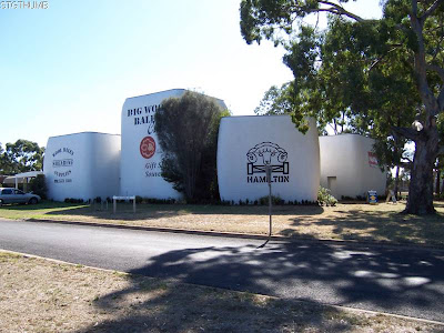
I forgot to mention the photo below - it was taken as we came into Hamilton - we saw the tourist sign and it said 'big wool bales' and we both thought maybe it might be some giant sheep wool bales but instead it was these buildings that 'look' like wool bales.

We were extremely disappointed that it was something like the giant pineapple, or lobster, or something like that!
Anyway after a long agonisingly slow day to get here to Penshurst we were over it! And to top it all off when we got here to the caravan park I hadn't unclipped my left foot and only my right and I fell as I stopped thinking that the bike would go right with the right foot already unclipped - no it decided to fall to the left where the foot wasn't unclipped and whooooopsie over I go! I have a graze on my knee and a bruised ego!!! I did the same yesterday - I was starting out after a break and the driveway was a little too steep for the gears I was in and I wasn't getting enough speed to change and I was slowing down and I didn't get my feet unclipped ... and over I went this time I landed on grass thank god!!! So Neil and I are keeping a tally called "SPD FALLS" where the SPD is the name of the pedals that clip the shoes in!
So the caravan here at Penshurst is nice - very basic and is a council one where you get the key to the amenities at the post office! It is costing us $9 to camp tonight ... bargain! It has clean toilets and showers and the washing machine is free - so we have done some machine washing rather than handwashing which is what we do nearly every day!
We are still not far from the Grampians and we can see them between the acorn trees and we are not far from the lovely Dunkeld.
Behind us is Mt Rouse and the town is at the base of it. Tomorrow we will be taking the Hamilton Highway to Mortlake and I will try to wake early so we can start before the wind!

Tuesday, February 23, 2010

Casterton to Wannon Falls


Casterton - Wannon Falls = 57km
Cummulative total = 822km
OMG what a day it has been! Stupid Janet was looking at the map again and decided to go through some damn hilly country (my excuse is that it "looked" flat on the map!!!)
But first, while we were at Casterton having a rest day there yesterday I went food shopping and saw a "black and gold" light fruit cake (my all time favourite cake) and couldn't resist buying it so you will see from the photo below they utter joy on my face when cutting the cake!

And no mum I am not wearing white shorts that is my tan line! I have to say this - my mother thought the photo of Neil in the pine forest bushcamp on the Millicent-Penola-Casterton page - she thought Neil was wearing a 'white' shirt and was surprised when we told her that no it was his body and it is the sun that has caused the brown arms and his body is normally that white!
On to today - I put my foot down and refused to take the shorter option of getting here to Wannon Falls via the Glenelg Highway ... well let me tell you I should have kept my mouth shut and followed Neil!
We took the C195 to Merino and then C 196 to Coleraine which were nice but hilly but it was very scenic in fact absolutely beautiful when cycling, so the hills weren't too bad and we did have a headwind all day. We turned of at a road called Winninburn and that is when it all started!

As you can see from the photo above Neil is taking the piss out of me and sulking like I did on the hot northerly wind day that we had a few days ago.

And he is still sulking because I choose this scenic but damn hilly route today!
This quiet road has moss growing on it so you can imagine that there is hardly any traffic on it. All we had was a few local cars pass us. But the steepness of the hills was unbelievable! I tell you it was almost as bad as Mt Hotham! Most of the climbs were short (around 1/2km at most) but some of the hill was around the 10-12% grade. Look at the agony on my face at the photo below!

I had to get out of the saddle quite a bit and sometimes I was leaning so far forward that I could inspect the condition of my front tyre!!! If you look closely Kouta is quite at home when I cruise at 4km per hour up the hills! One of the hills I just refused to ride and thought I could walk up the road quicker so I did and believe it or not I managed to walk up the hill pushing the bike at the same rate at which I would have ridden the bike!

I would say there was around 3 major hills to climb and most were in sections and not just 1 complete hill. But Neil didn't mind the climbs he found them hard but could ride them all.

But some of the down hills were fantastic (see photo above) and they were just as steep as climbing them.
At least along these quiet roads once you got to the top you tended to ride along a plateau and the views were sensational. So you could say that it is probably our most scenic ride so far but also our hardest one!
Just before we got to Wannon Falls and before we dropped down to the Wannon River we managed to get a good view of the Grampians and in the photo below you can see Mt Abrupt on the left and Mt Sturgeon on the right.

Right now Neil is looking at the map and I told him that I would ride the Glenelg Hwy but he has just informed me that we can take a back road ... now I am not sure if he is still taking the piss out of me when he says that .. you know Neil!
So tomorrow we head for Penshurst and I think it is a short day (if we take the Glenelg Hwy!) but who knows how far when we take the back roads!

Sunday, February 21, 2010

Millicent to Penola to Casterton


Millicent - 10km West of Penola = 65km (ridden Saturday 20 February)
Cummulative total = 711km

Again this is a delayed blog due to no service where we are. So I have left until we have arrived here at Casterton. We woke nice and early Saturday morning mainly due to the fact that we both didn't get much sleep due to a couple of dogs across the road continually barking throughout the night. But it was good to get up early as it was forecasted to be a hot day. And we couldn't exactly have our breakfast in the kitchen as that didn't open until 8am and by that point we were well and truly packed up and getting ready to leave.
We began with a solid headwind and within 5km I had had enough of it!!! One thing I can’t handle is Headwinds - I don’t know what it is but just a full on headwind really annoys me! I suppose it is the fact that I am petrified of running out of energy by the time I get to my destination. But after a while we decided to take turns at being at the front as it was beginning to get too much for me. Kouta was okay and didn’t throw himself around as much ... just so long as he can see Neil he is okay. The road to Penola was varied - anything from open farmland, pine forests, hills (mt Burr) and gum forests. Eventually the wind moved more westerly and the road swung round towards the east more and so the wind became more of a cross head wind so it was easier to ride side by side. It was a nice road and there was hardly any traffic.
During our cup of tea break Neil just had to take photos of what Kouta and I looked like!

Little Kouta trying to find a cool spot - it wasn't sunny or anything just a very hot wind!

Whereas I was just 'over it'!!!
It began to heat up and the wind was really strong and continually kept pushing me out towards the middle of the road so by the time we got to Penola we were buggered. We found the campground on the edge of town and it was full. We didn't really think about that it is coming up or it actually is grape picking season. However the caretaker/owner was very rude and abrupt to Neil which was completely uncalled for and so as we were riding into town to find the information center I was quietly thinking about what I was going to write about on this blog about the caravan park!
So once in the information center we had 3 options: 1. $125 basic cottage (takes dog) 2. $135 accomodation (also takes dog) or 3. Bushcamp in a pine forest 10km west of penola. Which one do you think we took?

As you can see we took the $125 basic cottage option!!!
Nah this is the bushcamp in the pine forest west of Penola. Since the road to Casterton runs in a westerly direction we had a tailwind so that was pretty lucky and it also took 10km off tomorrows ride. But before we got here we took a nice long break in the local park and had 2L of nice cool guava and apple juice and a sally lun which was very refreshing since it was so hot by now it was around 38 degrees. We filled up with water and cycled here to the campspot and loved it instantly - a degree or two cooler in amongst the pines. Much better than that rat infested, crowded, feral, disease ridden, poxy campground back in Penola. You know while we were in the park Penola looks like a really nice town, fully of knick knacky boutique shops and the other accomodation in B&B etc look really nice, albeit expensive! So I think Penola gets the thumbs up but just avoid the awful campground. On one of the campground guides we use I did read a not so good review about it and now we have encountered the rude prick of an owner I think yeah I wouldn't recommend this campground to anyone!
So Neil has broken a spoke in his rear wheel and tomorrow he will take Kouta and tent (light load) and I will take the luggage (the heavier load) ... lets see how he goes with Koutas constant moving!


10km West of Penola - Casterton = 54km
Cummulative total = 765km

Man I am over this computer, all afternoon I have been trying to copy and paste onto this blog but it is not allowing me to paste directly onto here and I can't understand why - sometimes it lets me do it and sometimes it does!!! grrrrrrr!
Anyway the ride here to Casterton was lovely - such a quiet road the C198. We hardly had any cars until around 10.30am and even then it wasn't that many.
So again we started nice and early and like I said today I had the heavier trailer and Neil had to take a photo of me coming out of the pine forests struggling through soft sand!

Actually it wasn't that bad once you got your momentum going you didn't really notice the heavier weight but what I did notice was the fact that the baggage didn't move! Which is one thing Neil commented on straight away (Koutas movement and how it affects your steering of the bike) and it took kouta around 30mins to settle down. But he was good for the rest of the ride except for when he needed to get out and go for a 'dump' and he starts to move ... alot!!!
Around 10km up the road we came to the SA/Vic border.

Ah it is great to be back in Victoria - on normal time and with normal drivers (hopefully!)
Since Neil was in front he set the pace and he rides a little faster than me and at times I struggled to keep up! There was hardly any wind and the road was flat so he sat on around 19-20km per hour which is quite a rate to maintain over 3 hours. During the last 12km we slowed down a bit as the road became a little more hillier.

At this point we were surrounded by State forest which was full of gum trees and snakes I suppose (not good camping spots!) and this led us into Casterton around lunchtime. Just before we got into town Neil took a photo of this Mary Mackillop sign which pops up alot around this area especially Penola (it is a pity the Penola campground owner/caretaker didn't take a leaf out of Mary MacKillops book and show a little compassion for 2 weary cyclists ... no instead he had to be a right little sod!!!)
I am sure that if you enlarge this photo of me you can see all the dirt and grit on my face since I haven't had a shower for 2 days and since both days were stinking hot I think Neil, Kouta and I really were a bit on the nose!!! In fact I hadn't shaved my legs for 4 days and you could say I was looking like an oversized echidna!!!
Anyway we are resting here tomorrow and the campground at Casterton is in amongst the local rec grounds, pool, bowls club etc but it is nice and quiet (hopefully!) and a caretaker will be along shortly to collect the fees. We have decided to go for a powered site ($3 extra) so we can use the computer at the tent and watch "Madmen" rather than have to go over to the pokey little laundry that is hot!
Oh when we got here Neil points out to a shop that sells everything ... including craft things oh I am off for a looksie tomorrow ... can't buy anything but I can look!

Friday, February 19, 2010

Beachport to Millicent


Beachport - Millicent = 35km
Cummulative total = 646km

It was too late last night to put up the photos I took from our rest day at Beachport so I will do it now.
Basically we woke with stiff legs so we decided to go for a walk after breakfast to loosen them up a bit. Well we just walked and walked and walked and I think even Kouta was sick off it! We walked down to the beach and saw Australias' longest pier (I think it is!). It is 772m long but it was originally built at 1220m long back in the 1880's but the building of it wasn't exactly great and it was never considered safe - see even 140 years later things haven't changed ... re insulation and solar panel fiascos!!!!

We ended up walking the length of the pier and it was cold and windy and by the time we got to the end of it Kouta was ready to go back home!

As you can see Kouta is leading the way back to land - funny though when he isn't interested in what is ahead he will drag behind but when he wants to go towards something that he likes he will walk in front and lead the way!
Once we reached land we decided to check out the other caravan park at the start of the town and by far the Southern Ocean Tourist Park is the better one not so exposed.

Beachport is a rather small place but is lovely although since it is on the coast it is directly affected by the coastal sea breeze and let me tell you it blew really cold yesterday, luckily it was sunny as you could sit in the sun but once in the shade with the wind blowing it was very cold!

Before we turned around and headed back to the caravan park we took a wee rest and as you can see Kouta is making the most of it!
For the rest of the day (until I was on skype with the family) I was "beached az in beachport"!!! we just laid around reading our books.
This morning we woke to no breeze and a bright clear day - lucky for us as we were expecting a headwind back to Millicent. However at 8am a fog rolled into town and it hadn't lifted by the time we left and that severly hindered our visibility but after about 15mins the fog lifted or more the fact that we began to ride inland more!
So it was a short day here to Millicent and we are to pick up food supplies for Penola tomorrow as we don't think there will be much there in the way of a general store. While setting up our tent yet another section of the aluminium pole snapped - see photo below.
This is the 2nd section to snap this trip (lucky we have bought extra along with us - 5 at least) but what bugs me about this is that all the fandangle expensive tents have these crappy aluminium poles (for the lightness of the total tent weight) which are straight and not curved to allow for the 'dome' part of a tent ... stupid really. I think we will be replacing all the aluminium poles with the slightly heavier fibre glass ones which tend to cope with the bending or curving of a dome tent.
The lakeside caravan park here in Millicent is really nice - excellent and clean facilities and we are in shade for most of the day. At the moment not too many tourists have turned up to this park.
But Neil and I have decided that as we travel between the states we will be examining the driving skills of each state and between Victoria and South Australia so far SA are the worst and most dangerous drivers of all - they are just absolutely mad, mad, mad and idiotic when driving! And it is across the board with regard to age and sex!
So tomorrow we head for Penola which is our last town we visit in South Australia.

Wednesday, February 17, 2010

Mt Gambier to Beachport


Mt Gambier - Beachport = 90km
Cummulative total = 611km
Yesterday while I was doing the blog I accidently deleted a few of the photos from the Sinkhole and the photos that are in the last blog posting don't really capture the true effect of the garden in the sink hole so I have added more below. The photo below was taken from the rim of the sinkhole so you are looking down into it.

Again the photo below you are still on the rim and this time you can see the limestone wall and how it has eroded to create a huge hole in the ground.

And this one is taken from the bottom of the hole looking up towards the rim.

It's a fabulous place!
Anyway onto today ... well we had quite a strong tailwind today so we decided to combine 2 days cycling and do it in 1 day!
We hadn't planned on doing it this way, intially it was going to be to Millicent today (55km) and an easy day tomorrow to Beachport (36km), however once on the road the wind was directly behind us. We ended up taking the B1 road to Millicent which again went through logging country but the road was really weird - firstly, they had major road works on the edge of Mt Gambier and that stopped traffic for quite a while so further up the road the traffic overtaking us was in groups (good for us!!!). Secondly, the road carried alot of logging trucks so the road itself was made to cope with the heavy loads and the lanes were wider than normal (maybe due to the big trucks). Thirdly, the road surface was sometimes rough and then sometimes smooth and so was the shoulder - sometimes it was soooooo smooth while the road was rough and vice versa! Fourthly, sometimes the shoulder was there, sometimes it wasn't and sometimes it was wider than the actual lane itself!!! So it definitely was a mixed bag today.
The road through to Millicent was scenic in itself with pine forests of varying sizes everywhere and the road wasn't overly undulating, it was just right!. Just before Millicent we saw a wood chipping factory and I made Neil take a photo of it!

A little further down the road there was a Kimberly Clarke sign which is the toilet paper people so we think those woodchips in the above photo will soon become our toilet paper!!!!!
By now the pine forests were gone and in the photo below if you strain your eyes at the end of the road you can see white poles which are actually wind turbines which stretch to the left of the photo and go for miles just like the ones at Yambuk.

At this point we were feeling quite good and the legs were feeling strong so we got to Millicent and decided that we should make for Beachport and then that will give us an extra day up our sleeves when we come back to Melbourne as I think we will be having head winds all the way back and so we may need an extra rest day!
The B101 road to Beachport is flat and goes through farmland and marshland. At times the wind was slightly to the side of us and it was so strong that it would blow me over into the line of cars! lucky there wasn't much traffic around. Generally we cruised along at 20 - 22km per hour which is pretty good going albeit wind assisted!
In the last 10km the legs began to feel it and tighten up but they made it! Beachport is not as big as what we thought it would be but it has a small general store for us to get our dinner each night. There are 2 caravan parks and the first one as you get into town is on the beach and the wind is blowing and there looks to be not much shelter from the excessive wind chill. So we found the 2nd park which is sheltered alot more from the beach. It is a Millicent Council one and it is huge and all sights are powered. It has a camp kitchen and BBQ areas. It is not full but there are groups of caravaners and at the moment Neil is chatting to 2 couples that are opposite us. It is a dog friendly park and everyone is friendly.
Neil said there is a salt lake back on the main road that is meant to be good to swim in so maybe we might go there tomorrow!

Tuesday, February 16, 2010

Rest day @ Mt Gambier

It was a lovely day today the morning fog lifted to a very bright sunny day today. We mapped out our morning to see a few of the sites where we knew the dog would be no problem. Our first stop of Valley Lake which is at the top of the hill and to the left (the blue lake is to the right).

Kouta looks so interested doesn't he! As you can see the water in the Valley Lake is not as blue (in fact it is normal colour) as the Blue Lake water. I can't figure out the blueness in the blue lake river as someone in the campground said they went to the blue lake in the evening and it was a greyish colour so maybe it has something to do with 'sun'?
Anyway stopped of again to take photos of this blue lake (I am fascinated by it!).

At least Kouta looks like he is marginally interested in this photo!

Man we look like vagabonds in this photo!
From here we cruised down into the city centre and east to the Umpherstone Sinkhole which is a large limestone hole in the ground and through volunteers they established an english type garden throughout it. It would be beautiful to see in Spring when all the flowers are in bloom. There is a stairway down to the bottom and you can walk behind the hanging vines.

they have even created wooden windows and shaped the vines around it.

Behind the hanging vines was really cool but at the bottom of the garden it was quite warm. In fact as you walk around it smelt like it was a hot house.

Just near this sinkhole is the Carter Holt timber mill where all the pine in the district is delivered and processed and the planks of pine timber that is being stored outside (and there is heaps of it!) give the surrounding parkland a lovely smell.
Not too sure where we will be going tomorrow depends on how we feel but we will still be in South Australia ... one thing I haven't quite got use to is the fact that they are 30mins behind Victoria in time and Neil and I forgot that there was this time difference in fact it doesn't really matter to us as we don't really have any appointments involving a time!

Monday, February 15, 2010

Pine forest bush camp to Mt Gambier


Bush camp - Mt Gambier = 52km
Cummulative total = 521km

Well here we are at Mt Gambier the unofficial "Bogan Capital" of Australia!
I didn't get too much sleep last night - must have eaten something bad and I had a sore tummy and I suppose to get a sore tummy in a bush camp is not really ideal but I managed. I tell you it was really DARK out there when there is no peripheral light, in fact it was scary as even the sky is covered from you due to the density of the pine trees!
Nevertheless we woke to another grey day but there was a hint of blue at times. It was a nice ride to Nelson much like yesterday. What surprised me was that there wasn't a lot of trucks and of those that passed us they were very courteous and gave a plenty of room or gave us a little toot - I presume the 'toot' means "by their judgement with on coming traffic they can't move over too far so it is better that you guys do"!!!
We got to Nelson 15km down the road and that is a cold windy spot when a southerly is blowing, you definitely need your thermals there, so we didn't stop long and just 4km later we crossed over into South Australia.

And straight away you notice a change in the roads with regards to shoulders ... there is none! If a truck coming both ways happened upon you you basically had no choice but to get off the road! But luckily that didn't really happen. Fortunate for us we had a tail wind in our favour, although the roads were undulating, the wind wasn't quite enough to blow us up the small rises so we still had to manipulate the gears to get up the damn things. But it was nice riding along there and still it was grey skies and almost threatening to rain!
The strange thing about SA is that there is no signage for anything really and if there was they didn't really give you enough warning ... I mean going into Mt Gambier you had no idea how far it was to go until you arrived there! Even campgrounds all they gave you was a few hundred meters warning and not "pine country campground" 3km this way!!! Bizarre! but one sign we did see (no warning though so we had to back track!) and that was for "free onions" so we grabbed some (not much left though) for tonights and tomorrows dinner.
So we got to our campground at the base of the hill to the blue lake. Had some lunch and then rode into town to Woolworths which was 4.4km away - basically up and over the hill! Now going up the hill the lane was very narrow and so cars couldn't really overtake but going down the hill in another street the road was 4 cars wide!!! Bizarre this place is!
Anyway I was warned that Mt Gambier was Australias 'Bogan Capital' and after Neils debarkle in Portland Woolworths with the orange stickers and bakery dept I decided that I would go into the supermarket to only get what we need! As soon as the door opened there were 2 bogan females! but wait there are more of them ... they are everywhere! ... they really are bogans! heaps driving around in their cars .... in fact the cars are full of them! Of course they are completely harmless but I could not believe that some many congregated in one town!!!
I got our necessitites and on our way home we stopped of at Blue Lake Lookout. I could not believe just how blue this water is!

It was also very windy around the rim so poor koutas' hair is a little messed up in the photo below.

I don't think my photos do the colour blue justice - I mean it is a real aqua blue and so beautiful. Once winter hits the water goes back to a greyish colour apparently but changes colour over the summer months. Tomorrow we will go see the other lake.
the campground is nice and the unpowered site is huge and has plenty of shade which is just as well as the grey skies broke and it was a lovely clear blue afternoon. The campgruond is not crowded and the facilities are good with very clean showers and toilets.
I forgot to mention that Mt Gambier is quite hilly hence its name!