October cycle tour map

October cycle tour map

Pages

Saturday, May 8, 2010

Rest day @ Parkes

Well we really didn't do much today here at Parkes - the Dish I found out is 15km north of Parkes in a place called Alectown which is on the Newell highway so we won't be passing that since we are heading on another quieter road to Dubbo rather than the Newell highway - it is not that important to see the dish that I would risk all our lives on the Newell Highway!
This morning Neil went shopping for a temperature guage and picked one up in Woolworths along with the groceries! he is very happy with it and can't wait until the morning to just see how cold it is in the tent and then how cold it is while we eat brekkie!
Then in the afternoon I went to get a haircut which I didn't like how she did it - it made me look old! so I asked her to take a little more off and do a few things and in the end I couldn't wait to get out of there! But now I have had a shower and washed out the ridiculous style she gave me I think it is okay ... nothing a helmet won't hide!!! That is the problem when going to the hairdresser I can't see what they are doing as I don't have my glasses on and it is not until I put them on do I see what they have done!
After that I rang my crazy family in NZ to wish Mum a happy mothers day for tomorrow as I don't think we will get reception at Yeoval.
At the back of this caravan park is a footy field and it is full of galahs that do nothing but eat the seeds from the grass, at times there must be at least 200 of them but in this photo I reckon there is about 100 ... you can count if you like!

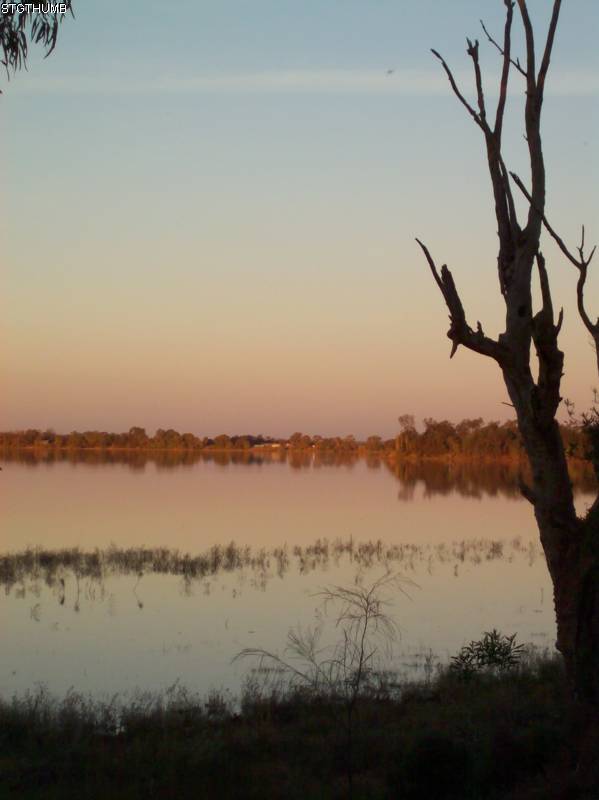
After the phone call to NZ we took a walk up to the Memorial Lookout which is not far from the park and you get to see the surrounding area and where we have been and going.


This is looking South East towards Canberra

This is looking more South towards Melbourne (sort off!)
Tomorrow we climb up and over the ranges but I don't think the climbing is too difficult as it is spread over 30km at least and then it is mainly down (with the odd up) to Yeoval (pronounced Yow-val) where our camp is in the local showgrounds. Should reach Dubbo Monday.

Friday, May 7, 2010

27km West of Forbes to Parkes


27km West of Forbes to Parkes = 79km
Cummulative total = 1368km
Here is a photo of our bush camp (I forgot to put it on the previous post). There was even a tree stump that I could use as a little table. This is our first bush camp for this trip and as per usual I managed to spook myself out by convincing myself that we were going to by attacked and murdered ... so much that I had nightmares last night of being knifed and so I have been awake since 3am this morning! Before going to bed I had to see the sky as I always thought that you could see more stars in the sky in an environment that is lacking light ... and I was right there are some many stars in the sky when you don't have town/city lights around you! But man it is pitch black when you turn your torch off ... scary!!!

Before we started this morning I wanted to try and get a group photo of the 3 off us - that tree stump really came in handy for this photo!

Even Kouta looked at the camera!
It was an easy ride to meet up with the Newell Highway 6km south of Forbes but once on there the traffic was horrendous and the shoulder was narrow. We had a cuppa in Forbes and decided to take a longer and back road to Parkes. We had to seek out the information center just to check to see if the road was sealed.
It was sealed but they sort of forgot to tell us about the major road works that is going on. They had ripped up at least 2-3km of the road and at times the way was quite rough! But otherwise it was great riding except of the last 24km where the road turned east towards Parkes - the road was terrible! ... Neil and I have a theory and it goes something like this ...
... Parkes is probably most famous for 'the dish' which was responsible for the world seeing the first man on the moon images ... now Neil and I both think that the reason why Parkes was chosen as a key factor in showing the man landing on the moon was because it was the closest to this road that we were cycling on, I know you are asking yourself what am I talking about?! ... the road we were cycling on looked exactly like the surface on the moon (full of pot holes and craters) so we think that Neil Armstrong and Co. were actually staying in Parkes and they came out to this road in a bubble suit and with special effects and a stary night backdrop they pranced around on this particular road!!!! meanwhile every living room in the world were seeing the images from Parkes thinking it was the moon but it wasn't it was really this road (Brolgan road I think was the name!) ... do you like our theory!!! We have another one ...
... They didn't actually use the Brolgan road we were on but they used ALL the streets that are in Parkes as they ALL are full of pot holes and craters!!! crikey I have never been in a town with such crappy roads!
Nevertheless Parkes looks like a nice town and we will be staying here tomorrow so Mum if you could turn your computer on when you get home from work I will give you a skype call around 6pm NZ time as I am not too sure if Yeoval (sundays destination) will get internet reception!

Condobolin to Bushcamp 27km West of Forbes


Condobolin to Bushcamp 27km West of Forbes = 74km
Cummulative total = 1289km

Well it wasn't as cold last night as what it was forecasted (forecast was a low of 4 degrees!) but we find that the first 2 hours after sunset are alot colder than 6.30am in the morning!
We had a latish start this morning, we headed in a south east direction towards Forbes, we knew we would have to bushcamp tonight and the Camp 5 book said Straneys Bridge (63km away). The Lachlan Valley Way is the road to Forbes and it is flat but we had cross to headwinds most of the way. To make matters worst the road was really crappy - chunky gravel road the is very bumpy and towing the trailers makes it even harder!
Kouta doesn't like that sort of road (and neither do we!) we think it has something to do with the constant minor vibrations that you can feel coming up the bike as we have to constantly shake and move our hands more than normal or else they get pins and needles! Even when we crossed over the shire boundary the road did not improve!
Looking along the way there wasn't much opportunity for bush camping as there are alot of farms right up and along the river and road frontage.
We didn't encounter the Lachlan River until around Warroo but we did find a bridge that crossed over a creek and we stopped there for a cuppa.

If you are wondering what I am doing I am actually running on the spot - it was a damn cold wind and the clouds began to build up so it hid the sun most of the day!
Not too sure if this creek is used for the irrigation of the surrounding farms - more than likely it is as it wasn't really flowing at all.
Knowing that we were bush camping tonight we had a full load of water with us except the bladder as we were hoping to full the bladder up along the way at some local halls rain tank! No towns along the way just 2 localities and the first one Fairholme had nothing but there was a hall at Warroo that had a rain tank with a tap so we filled up the bladder.
Just before Warroo we took a rest break and the gate at the driveway was opened and there was sheep close to the gate (couldn't get through as there was a grate across the gate) so Kouta was on one side and the sheep on the other and all Kouta could do was look longingly!!!
At 63km we reached Straneys Bridge rest area which was suppose to be our campspot along the river but decided it wasn't suited for tents as it was very exposed.
We decided to continue and search for an ideal spot which as we went was looking less and less likely! 10km later we found a dirt track and followed it and voila! we found the perfect campsite. Obviously someone had been there before as there was the remains of a camp fire. The spot was secluded and well of the road and beside the river but to get to the river there is a steep bank so we couldn't really dip our toes in to see how cold it was!
I was rather relieved to get to a spot as Kouta constantly threw himself from one side of the trailer to the other ... for 74km he did this! and it makes it very hard to control the bike!

Wednesday, May 5, 2010

Tullibigeal to Condobolin


Tullibigeal to Condobolin = 68km
Cummulative total = 1215km

We arrived in Condobolin in good time today and it was a relief as we cycled into the town that we could see a communication tower which meant that we will get internet connection and catch up from yesterday!
So we woke this morning and new the wind had swung around to the south west west direction as there was lightening and thunder and rain last night and this must have frightened Kouta as he decided to go up and sleep near Neils head last night!
It was a grey cloudy beginning to the day and this quickly blew away to bright clear skies! While packing up this morning I came across a huge moth on one of my front panniers.

They are harmless and this one is quite small, I have seen a bigger one at Port Campbell a few years ago and that was huge!
Below is a close up of it!

I would say it was around 8cm long but it didn't spread its' wings - now that would have been a sight!
So we left Tullibigeal and the road was fabulous until it became a one lane road with patches of gravel between sealed parts of the road! But it wasn't bad and it was a change from the sealed road. We joined the Lachlin Way road and went east towards the main road the runs from West Wylong and Condobolin.
It is lovely riding around this area and the first half of the ride you can feel you a climbing gently and then around half way you go over a small range and then down and along to Condobolin!
Not long after lunch we were just climbing up the last small hill of the range and Neil spotted a dead snake along the side of the road (it was about 1m in on the gravel part) and I had missed it so we went back to have a look and it was at least 1.5m long and Neil thought it looked like a Brown snake (so it was a poisonous one!) and by the way it was lying we think something ran over it and broke its' back. From then on I had my eyes glued to the stony part of the side of the road! I must have had a temporary lapse in concentration to miss that one!
The second half of the ride went through alot of pastoral land and all along the side of the roads are the very old telephone lines which are no longer connected up but the poles are about 2.5m tall so they are quite short.

Just before we got to Condobolin we came across a rest area about 15km before the town and it would have been a lovely campspot for the night but I think it is too close to the road!

Neil liked the billabong that was at the rest area but really it was connected to a creek. I would imagine the mossies at night would be thick!
We got to Condobolin around 1pm and the campground is another council one, in fact it is run by the same council as Lake Cargelligo, but the Lake Cargelligo campground is by far better!
The town is big and has a population of around 3000 and the IGA is huge! It has everything in that IGA - even a very small craft aisle!!!
Tomorrow we follow the Lachlin river and head towards Forbes but will be camping in a rest area somewhere along the Lachlin river.

Lake Cargelligo to Tullibigeal


Lake Cargelligo to Tullibigeal = 46km
Cummulative total = 1147km

It was just a small day to Tullibigeal - we had a choice early in the morning whether or not to make the 90km ride straight to Condobolin or take the longer way via Tullibigeal ... basically it was the wind that dictated which way we went and since there was a very very strong north north east wind we opted to go to Tullibigeal with a severe cross wind. I said to Neil for the past 2 weeks we have been cycling in this area and the wind each day has been virtually non existent and what do you know we get this day which has 30km per hour winds! it was just like cycling in Victoria!
The road was nice and quiet and we didn't get much traffic. So not alot happened to us only that a group of Kangaroos decided to follow us alongside the road. At first I saw one in the middle of the road and I got really excited as we hadn't really seen any wild kangas this trip (only the ones crossing the campground but that is because it is near a state forest and to me that basically counts as something similar to a zoo!!!). Well it quickly bounded off as a car was coming and Neil didn't manage to see it and since he didn't see it he decides that I must have been seeing things! Next thing you know the same one is about to cross the road again as we pass it and it quickly decides not too and joins a group in the bushes which then begin to bound along and cross the road in front of us for at leas a km or 2!
Then not long after that we pass cattle grazing on the side of the road and I was worried as we passed that they would bolt and bowl us over! But they just stopped in the middle of eating and looked up at us as we passed. Not even Kouta was interested in them! But he was very excited when the Kangas were bounding around us!
So the turn off to Tullibigeal was around the 43km mark and it is a small town with no campground but they do have a Pioneer park and the Showgrounds which they open up to tourists so that they stop and I suppose maybe buy something in the 2 shops and this way it sort of keeps the town alive. So we pulled up to the Pioneer park and there are 3 caravans already there and 1 has been there for at least 2 weeks! It is free and there is a shower and toilets. There is also a kids playground so we set up our tent in the corner of it.

As you can see our bright yellow tent blended in quite nicely with the red, blue and yellow playground!!!
So late in the afternoon we bought a drink and 2L icecream from the co -op store and unlike when we were cycling in America 13 years ago we couldn't finish the icecream. So we let it melt and poured it over our fruit cake for dessert!!! yummy!
We went for a walk to see what the showgrounds was like and in hindsight I think that would have been a better option for us in the tent. It had a fabulous view!

This is the view if we decided to camp in the showgrounds!
Tomorrow we head for Condobolin.

Monday, May 3, 2010

Rankin Springs to Lake Cargelligo


Rankin Springs to Lake Cargelligo = 71km
Cummulative total = 1101km

The morning we rode this was somewhat cold - it didn't feel cold at night but as we were moving about our toes were cold and I did contemplate putting socks on under my sandles (we both don't have covered shoes but sandals and jandals!). I think there was a very slight frost as my cycling shorts that were out drying (or trying to dry) over night had a very thin layer of frost on them. However it was warm in the sun and once we got cycling the toes soon thawed out!
Again we continued on a quiet road and since it was a Saturday the majority of traffic was going opposite to us and heading towards Griffith and maybe 5-6 cars over took us throughtout the entire ride! For the first 30mins of cycling we climbed over a gap and then the road ran between 2 ranges. We both thought the scenery was absolutely beautiful. I really love this sort of country - extremely blue sky, bright red dirt and green trees and since the rains late last year it has really made this area lush and I mean LUSH! Even under the trees there is a green cover of grass so it must have had alot of rain (maybe from the St George floods?).
The road is no longer absolutely flat and it is more undulating but not hard to ride. Below is our view while we had lunch on the side of the road about 34km south of lake Cargelligo.

Beautiful isn't it!
Not long after our lunch break, about 3km up the road, we were stopped by a local farmer who wanted to have a chat to us and like most people around here he was absolutely gobsmacked that we were cycling around here! He himself is a cyclist and had not long come back from a guided tour in Sri Lanka and had done alot of guided tours throughout Asia. He also said that this time last year this area had nothing and things were looking very sick and dry (due to the drought) as we commented as to how green it was around here.
From there the road ran through a State Forest so ideal camping spots along the way.
We got to Lake Cargelligo around 1.40pm.

And listen to this! ... the town was closed! Nothing was opened which sort of stumped us for a while! Even the 2 grocers were closed and what made matters harder was they were both closed the next day! (Sunday). Crikey, after living in a city where everything is open 7 days a week and we were warned that small towns will shut down Saturday afternoon and Sunday ... it still was a shock to us!
The Bakery was still open so we got bread and it was also a takeaway so we thought we could get our Sunday dinner there and make do on Saturday with what was in the pannier bags - Noodles and curry tuna which we made into a soup and it was absolutely lovely it just needed a few veges!
We found the campground which is a council one and I have to tell you this is a BRILLIANT caravan park and more people need to get out this way to appreciate a clean and tidy caravan park! It costs us $13 to camps unpowered ($16 for power) and it has a camp kitchen that has tea, coffee, sugar, detergent, free bbq, toaster, microwave etc. And that is not all - the toilets are beautiful and clean! and believe it or not (and this is in both male and female toilets) they have shampoo, hand cleaner, body wash and cotton buds for you to use! Now that is an excellent campground! We both rank this campground as the best we have EVER been in (and we have been in alot!).
So I am writing this on Monday and we will move on tomorrow towards Parkes. We decided to stay an extra day here since it is an ideal spot especially since Kouta can move about better and doesn't have to be chained up (which he hates!) like he has to be in alot of the council parks we have come across.
The weather has been good for us - it is currently in the mid 20's and a beautiful bright sunny day and even the nights are not cold (around 10).
Here is a photo of our campspot.

The lake itself was empty last year (like alot of lakes!) and is not quite full at the moment and you can see where grass and shrubs have grown when it was empty and it is not all that big.

At sunset the lake looks nice and if I could get up before the sun I would to get a photo of the lake at sunrise!
But otherwise here is the lake taken at sunset!

Griffith to Rankin Springs


Griffith to Rankin Springs = 67km
Cummulative total = 1030km

I know I haven't posted for a few days but we got to lake Cargelligo and we couldn't get reception the first day, dial up the second day and now we have a connection that can cope with the up loading of photos so I will begin from where we left off ...
Back in Griffith we met a lovely couple from a town in Victoria called Colac and they came up to Griffith and were staying in a lovely cabin at the same caravan park as us. Here is a photo of them.

It was lovely with this couple they let Neil drive their car around Griffith and Leeton looking at the sights, they bought our dinner for the 2 nights we were there and even let us hang out in their cabin and they didn't mind little Kouta!!!
So we bid a farewell to Neils parents around 9am and began cycling north towards Rankin Springs. It was a quiet back road with hardly any traffic and it followed the Ural ranges which I think is part of the Cocoparra national park. There were still orange groves and vineyards just north of Griffith.

I would say that the orange groves weren't huge like some of the vineyards. Basically this is all we saw for at least the first half of the ride and then once the channels ran out (or the irrigation stopped) you basically entered wheat country.

Above is the typical view that we had after the irrigation finished. I like this sort of country I suppose it is because of the colours - blue sky, red dirt and army green trees!
Along the way neil saw quite a few lizards which I kept missing but as per usual there is one form of legless lizard that I always seem to see ... you guessed it a snake ... but listen to this! ... riding along on a quiet road basically like the photo above and I am riding about one meter from the shoulder and Neil is riding in the middle of the road and I always look to my left between me and the verge on the shoulder and ahead and I happen to look at the very front of my wheel and what did I see ... a very thin (about the width of a pencil) 25cm snake to the right of my wheel! As I rode past it I thought I ran over the very end of it but it recoiled and my first reaction and instinct was to gasp and to lift my feet and I began too and then I realised my feet are locked in and can't move so all this is happening in a split second and Neil is a little back from me and says that the snake wriggled away after the wheel of the trailer had gone by.
By now my heart was pumping that these little ones are just as poisonous as the adult ones and then I thought OMG I am a baby snake killer! For the next 5km I had the guilts that I killed a baby snake and then I got angry and thought what kind of mother lets her young on the middle of the road! Neil informs me that once the baby snake is born ... that is it ... it is on its own and has to fend for itself ... and then I really got the guilts, but Neil reassures me that is wriggled away and it was fine! But I tell you I looked ahead (and Neil does too) and you just couldn't see it, it was really camouflaged and we both didn't see it until we were on it!
Neil reckons it was a red belly black snake so it blended well into the road.
So at the end of our quiet road we joined up with the Mid Western Highway and had to go along it for around 15km. Which meant that we had to climb over the ranges. The road meandered through Sims Gap and although the hill wasn't big it was a gentle reminder that we have had absolutely flat country for the past 2-3 weeks!
The photo below is looking east at the top of Sims Gap.

This is facing east at the top of Sims Gap.

So after that it was a nice roll into Rankin Springs. This is a very small town with a population of around 250 and even then I think they have embellished and increased the population by including all the cats and dogs! We saw 2 people and that was the campground manager and his wife or mother - we couldn't quite figure that one out.
Rankin Springs does have a small walk which includes a few historical facts about the place and we did manage to take a photo of the old water tower that was used for the Steam Engines that would cart the wheat and grain along the railway line.

The campground is small and has no facilities except for showers and toilets. Even the drinking water has to come from a rain water tank and the tap water is not suited to drinking, with the lack of facilities I thought the price for unpowered camping was very expensive $14 a night and I get the feeling that he "fiddled" us since it is a council one. But you get places like that along the way!