October cycle tour map

October cycle tour map

Pages

Monday, February 7, 2011

Millicent to Beachport


Millicent to Beachport = 38km
Cummulative total = 484km
A nice short day today so we slept in a little bit. Before we set off we stopped by Woolworths to restock on a lot of food - it was open today!
The day forecast was for light winds and we weren't sure which way they were going to blow as for Millicent you got the Mt Gambier report and that said WSW winds and for Beachport you got the Robe report and that said SE winds - which ever way we had light winds almost none and if it did blow it was more a cross wind so I say it was more a SW wind.
We had been along this road before and the speed limit in SA is 110 in open roads and we can understand why there are so many black (death) and red (injury) markers on the side of the road! There is traffic along this road but not constant, no real shoulder to speak off the the surface is a little bumpy in places. It was good riding and we got to Beachport just on lunchtime. Last time we came here we had a rest day and it was fine but a very cold southerly was blowing so it was a little freezing - today it is fine and warm and the beach view is absolutely gorgeous!

Not many people around just the normal grey brigade in big groups so the campground is big and we are at the council one which is at the other end of town.

we are camped under a nice big tree that gives us shade in the afternoon - although it is a little cool in the shade as the wind has started to blow this afternoon.
We went for a walk this afternoon (much to Koutas disgust - he doesn't like walking when we travel I think because he is a little tired) and we walked along the beach shore line.

the above photo is taken with the camera normally and look at the colour of the sea -
now look below and look at the colour of the sea -

No they are not the same colour and there is a difference so don't say that you can't see any difference! the photo below is taken with my sunglasses in front of my camera lens. Hence why in brochures you see the water colour a brilliant blue green colour - that is not the colour of the sea but the damn photographer has used a filter!
Which ever way you look at the sea (with or without sunnies) the water colour is beautiful.
Beachport has a long pier which we walked along last year but Kouta wasn't really enthused about walking along it again.

It is popular with boaties and fishing and I can imagine that it would be a very busy place in the weekends.
Tomorrow we head for Robe which is alot like Beachport I think - I have never been up that way before.

Sunday, February 6, 2011

Port MacDonnell to Millicent


Port MacDonnell to Millicent = 75km
Cummulative total = 446km
I think I ate some dream fish yesterday as I had some strange dreams about the Mexican Cartel trying to kill us! We had fish and chips for lunch yesterday from the local takeaway at Port MacDonnell - the fish was okay but the chips were superb!
Anyway it was blowing all last night and we woke to a few showers but a lovely clear morning eventuated. While packing up the tent we noticed a big wet spot so some of the rain must have channeled under the tent and because of the puddle we also had an extra tennant under the tent!

can you see the little brown frog - a very good camouflage!
Anyway we set off with a raging southerly blowing and lucky for us our first 16km was going straight north on the road to Mt Gambier but we turned west at Bellum Bellum and we had a cross wind for about 16km. Along this very quiet road we took a break at Little Blue Lake - it is a great spot for a bush camp (a bit out in the open but there isn't alot around and the road is a minor one although probably not a good spot on the weekend there was alot of car skid marks around!)


It is a sink hole and the water is very blue due to the sun I think as there are warnings that the water contains algae and advise that if you have sensitive skin that you don't go in!
Lucky for Neil he found yet another pair of jandals/thongs. However way back at Peterborough he forgot to pick up his Nike pair that he found going up the Gillies highway in Queensland last year so these jandals will replace them!
We had a lunch break at Kongorong - now this is a sleepy little town and we saw no one around. It has a very good recreational park facilities - a well maintained footy field, netball courts, basketball court and excellent toilets and clubrooms.
From here we go North west towards Tantanoola and Millicent. The going is good as we have a tailwind again - strong but not strong enough that we don't have to pedal! we could sit on around 18km per hour. It is flat and I think maybe a few cars and trucks passed us - this is a very quiet road and I am not sure if it is because it is a Sunday or it is like that during the week - probably the latter.
Along the way you can see the huge wind turbines - Neil decides to try and count them and he estimated around 100 or more.


it is hard to see them in the above photo as they are miles away from us! Once we got to Tantanoola the legs felt a little weary and the road took us to the main road between Mt Gambier and Millicent and we came along this road last year. Our road came out near the Kimberly Clarke factories where they make toilet paper etc.
This Mt Gambier - Millicent road is a little busier but there is a shoulder. About 12km later we got to Millicent - now Millicent has probably got the longest stretch into town before you actually hit the shops - I would say there is about 3km of houses all along the highway before you get to the shops! I had a feeling that Woolworths was closed but Neil thought it might be but I was right I think South Australia is a bit like Queensland and closes on Sundays except the bigger towns and cities. Lucky for us the IGA was open and it is a reasonable one.
We have come back to the same campground as we stayed at last time we were here and it is very quiet and right next door to the town swim hole which is too cold to go in - that southerly wind is still blowing and it is very lazy!
Tomorrow is a short day to Beachport so we will swing by Woolies and pick up supplies.

Saturday, February 5, 2011

Rest day @ Port MacDonnell

It was good to have a break today and what started out as a fine day ended up being very grey and gloomy with just a sprinking of rain everynow and then. We did manage to get out and walk along the beach ...


it was nice walking along here but behind us the beach is littered with seaweed when the tide goes out and so it is a little bit smelly! Check out Neil - Mum you can see he is wearing that white shirt again!

When we got back we decided to ride into town along the bike path 1.5km and Neil passed through here a long time ago and remembered that he boiled up a cuppa in this bus shelter as it was a freezing cold day!

We continued along the bike path for another 2km and this took us to the base of a hill with a lighthouse at the top. The path then goes on the road but it is clearly sign posted that it is for riding and walking - besides there were no cars around!

I thought you would be able to go up to the lighthouse but it is fenced off - I assume that it is still in use. We continued on for a few 100m's and came across a sign for the old lighthouse and penguin colony.
It is a great view from up here and the rocks are so sea worn and rugged.


believe it or not this is called frog rock as the little outcrop on the top looks like a frog!

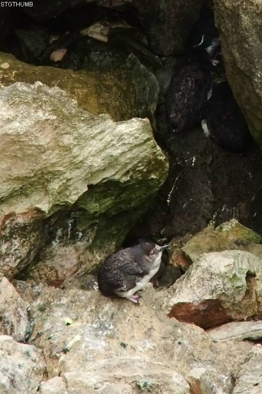
We did manage to see some fairy penguins - they are in a very secluded little bay and are nestled in amongst the rocks and can be hard to see - so I took some photos and along with alot of cropping in Kodak I managed to come up with these.


If you look closely behind this penguin you will see somethings that look like dark grey rocks with stripes - they are the fairy penguins!

Looking back at Port MacDonnell

more coastline!

This was taken along the breakwater - we rode as far as we could and then had to stop as the breakwater had caved in a bit!
So that was our morning the afternoon was reserved to chatting to NZ but for some strange reason the all appeared off line on skype so i assumed no one was around - then i get an email from dad asking where we were - his status on Skype showed him off line - man I was cursing him! LOL!!!
Tomorrow we ride to Millicent.

Friday, February 4, 2011

Rest Area 15km before Nelson to Port MacDonnell


Bush camp 15km before Nelson to Port MacDonnell = 46km
Cummulative total = 371km
We all had a good nights sleep last night and since this is the first bushcamp of the tour I didn't freak out like I did last time I camped here - I had a touch of 'Blairwitch project movie' going on last time!
We over slept as per usual and didn't get away until just before 9am. Just down the road we came across 2 emus (there were more according to Neil but I only saw 2) in a field and I managed to get 1 of them in the photo.

this one above was running to be with the other one but a car came past and scared both of them off so I couldn't get a photo of them together.
Heaps more trucks this morning - I assume we had caught them as they were going to Mt Gambier. They were all very courteous and we got heaps of beeps (positive ones if there is such a thing as a 'positive' beep!) and waves. Since the side of the road has been tacked on after the main road has been built that part tends to be rough so we ride out in the lane on the smooth part and move as soon as we see a truck.
15km down the road is Nelson and we took a wee break there. Nelson is small and has only a milk bar, pub and info center. It does have a caravan park - small and nice - it is called River vu caravan park. there was another touring cyclist there and he came over to chat with us - he is from Austria and is cycling from Perth to Sydney. he said it costs $10 to camp at the caravan park which is quite good value.

This is the lake(?) that is at the mouth of the Glenelg river and it goes out to sea.
Not far from Nelson is the South Australia - Victoria border.

From this point you go another few kms and there is a turnoff for Port MacDonnell but just before that turnoff is the place where quite a few of the trucks that were overtaking us go - to pick up Limestone and cart it all the way back to Portland to load onto the ships.
Along the Port MacDonnell road is nothing but farm land - milking cows I think and we did stop at some farm gate for a cuppa but the flies eventually got to us and we cut our break short!
A few kms down the road we came across a sign warning that stock was crossing and we got just before a farm and the farmer came out in his ute followed by an herd of cows - The farmer said it was okay to go through but then he saw kouta and said better not as the cows might get a bit antsy. so we stopped and watched the cows walk down the road.


Whenever I see a herd of milking cows I always remember a NZ advert about milk and 'milking with murray' was the catch phrase.
This is the 3rd day cycling for us and the legs carried me as far as the coast (12km short of Port MacDonnell) and then they decided that they were a little weary! So the last 10km was a bit slower! The scenery along the coast was nice - earlier on in the day it was clouded over but the sun was beginning to shine through now and there was a slight haze over the ocean.

It is not very clear because of the ocean haze but that is Port MacDonnell in the distant. It is famous for its Lobster and not shown in the photo is a fleet of fishing boats out in the ocean - I presume they are trying to catch Lobster.
We are at the campground just as you come into town and it is nice and quiet - not alot of people here and if they are they tend to me from Mt Gambier (just up the road!) or Hamilton.
We are on a powered site as it was only $3 more. There is not much shade but between the sites are hedges so we are hard up against a hedge to get shade from 3.30pm onwards.
South Australia is 1/2 hour behind Victoria so we are not sure whether or not to change all the speedometer clocks - I have forgotten how to do mine so I might have to just take 30mins of the time I see.
The campground has a kitchen with bbq, gas burners, fridge, toaster and jug and believe it or not the washing machines are free - so we have done our laundry. But you have to pay for your showers which is only 10 cents and that is for a while - I used 30 cents as I hadn't had a shower since Heywood and you sort of take longer when you haven't had a shower! Otherwise I think 10 cents would have been enough for me - definitely for Neil.
We stay here tomorrow for a rest day.

Heywood to Bushcamp 15km before Nelson


Heywood to Bushcamp 15km before Nelson = 63km
Cummulative total = 325km

We could not get either optus or telstra internet way out here in the bush today so I have copied and pasted the days blog from my files.
We had a good nights sleep last night and slept in a little bit. We left around 8.45am and headed south towards Portland. We initially were going to go across to Dartmoor via highway 1 but there seemed to be a lot of trucks heading in the same direction to Mt Gambier so we decided to go south a bit and cut across to Gorae and onto the road that goes from Portland to Nelson.
So went on highway 1 for around 9km - it was busy but it had a good shoulder so we didn’t get in the way of trucks. Just after the Surry river we turned west onto the Surry River - Gorae road and this was a lovely quiet road a bit hilly but ridable. This road joins up with the Portland-Nelson road at Gorae west but just before we joined this road we go one hell of a fright we saw a Koala on the side of the road and I think it also got a fright from us and I don’t think he was aware of us until we actual said OMG there is a Koala and soon as it heard us Neil said it lept onto the blackberry bushes and then started scrambling up a tree at that point Neil was off the bike and coming to me for the camera. The Koala by now had stopped about 2 meters up the tree and was watching Neil who was about 4m from the Koala taking photos.


I couldn’t believe it and it was very weary of us and kept watching us. Eventually it climbed a little more and sat in the crook between 2 branches safe in the knowledge that we weren’t after him.
We looked around for others but couldn’t see any and Neil said he didn’t see it cross the road as we were coming so it must have walked along the side of the road where the blackberry bushes were. We don’t think it was grazing on the blackberries as apparently they only eat one type of Eucalyptus leaf, but I wouldn’t be surprised if it was eating them!. We were both very excited about seeing this Koala because believe it or not it is, for both of us, our very first real wild Koala! Although we have seen them at Raymond Island (near Paynesville) and in the campground at Beechworth but to us they are tourist or conservation areas where everybody knows there are Koalas so they are wild but not wild in the sense that the Koala that we saw today was probably not going to be seen by anyone else and it is not in an area that is a conservation area or wildlife park - know what I mean. We see along the road the road signs saying Koalas in the area and we look but never see any and now today without warning here is one along the side of the road! Gosh we were both very excited about it and I made sure Neil got good photos of it!
Anyway we rode off on a high and joined the Portland - Nelson road. It is rolling up, down, up to Mt Richmond. We stopped of at Gorae west to pick up water as there is no where along this road for water. We found a tap near one of the small buildings near the CFA building - we won’t use it for drinking as we are carrying plenty but more for washing. We stopped at Mt Richmond were we had a cuppa at the 40km mark. From here it is down hill a bit and you come close to the coast and there is a great view of the coast as you go down the second hill.

From Mt Richmond on there are heaps of pine forests and plenty of areas to bush camp. The road is still undulating and the traffic is not too bad - a few trucks but when you here them come there is a shoulder which you can seek refuge in and then once they pass you can come back out on the road as the shoulder is very rough and the road is more pleasant to ride on.
The rest area is about 15km before Nelson and the blue sign saying it is 300m ahead is a bit wrong with regard to water - there are water tanks but the sign clearly says they are for fire fighting purposes and I doubt you would be able to find a small tap coming from the tanks! I also doubt the drinking quality of the water. Otherwise it is an okay rest area but there are pine forests opposite it so it is better to camp in there.
We have been along here before (a year ago!) and we decided to camp in the same spot (well almost) in the pine forests. It is nice and cool in here but unfortunately a few mossies that love to bite through clothing especially lycra!
At the moment we are all crowded in the tent resting and soon we will have dinner - guess what it is .... WEETBIX!!! yippeeeeeeeeeeeeeee!
Onto Port MacDonnell tomorrow.
A photo of our campsite in amongst the pine trees.

Wednesday, February 2, 2011

Port Fairy to Heywood


Port Fairy to Heywood = 75km
Cummulative total 262km
Before I start blogging about our cycle today I thought I would share a few photos from the mutton birds at Port Fairy. Unfortunately I couldn't get photos from them coming into their nests as they arrived at dusk and it was just too dark for the camera. However as I was waiting for them to arrive I did get a photo of their burrows in the ground.

These are all over the island and while we were waiting we did get to see some wildlife apart of mosquitos.

2 black wallabies were grazing near by. Like I said the mutton birds didn't fly back to their nests until 9.20pm and the sun was well and truly down by them. It wasn't what I thought it would be - I expected a big black flock to come in but instead you get this gradual increase in birds in the sky. They are very quiet and tehre is no squawking or screeching and I have no idea how they can pick out their burrow as they all look the same and I also have no idea how they don't bang into each other as they dart around in the sky!
Anyway onto todays cycle. We left just after 8am and there was a gentle south easterly wind which made riding easier for us as we were going North. So we had a good tail/cross wind as we took the road to MacArthur. It is a good road and not alot of traffic but just north of Port Fairy is a big stone/boulder place and as we went along we noticed there was alot of fields with rocks or boulders in them and we came across this in a field!

That huge round thing behind the ute is a stone cutter! it was a pity it wasn't going!
While going along you can see these wind turbines along the coast - these are near Yambuk and we passed them last year. In fact the campground at Yambuk is quite close to these.

The road is rolling and passes through some small towns like Orford and we turned west just before Broadwater. We had a cuppa at the intersection.

Like I said on a previous blog the area is quite green and they are still cutting and baling hay during February!


Taking a break in the shade.
We turned west around 11.30 and the wind had gone so we were left to pedal unaided! Not to worry this road is relatively flat and very quiet. To entertain ourselves today we decided to play a little game and had to establish how these small towns and places we go through got their names. For example, ORFORD - i came up with the fact that someone came along in the Orford area and said "oi ford this is a noice place"!!! I also came up with the reason why Heywood is called Heywood - someone came along and said "Hey woodya look at that!" But my personal favourite is Bessiebelle - this small deserted town is named after this bull

and his name is Bessie but when it came for the signwriter to spell the name out on the board he had no 'u's and only had 'e's so he had to spell it as Bessiebelle!!! Yeah okay it passes the time!
Most of the area around here is either grazing cattle or sheep or Australian Blue gum forests.
Eventually we connected up with the road that runs from Tyrendarra to Heywood. The legs were going okay but we were happy to get here.
The campground is north of the town just before the road splits into going either to Mt Gambier or Hamilton so there are quite a few trucks.
The place is very nice and quiet and we are tucked away down the pack under plenty of shade. The kitchen has basic facilities like a bbq, fridge, toaster and a sink for dishes. The water is a bit better than Port Fairy which is absolutely ghastly and has a very strong chlorine flavour - we had to by cordial to drown out the chlorine taste!
Tomorrow we are bush camping in the same place as last time we were here - in a pine forest on the road that leads from Portland to the border!