October cycle tour map

October cycle tour map

Pages

Friday, February 4, 2011

Heywood to Bushcamp 15km before Nelson


Heywood to Bushcamp 15km before Nelson = 63km
Cummulative total = 325km

We could not get either optus or telstra internet way out here in the bush today so I have copied and pasted the days blog from my files.
We had a good nights sleep last night and slept in a little bit. We left around 8.45am and headed south towards Portland. We initially were going to go across to Dartmoor via highway 1 but there seemed to be a lot of trucks heading in the same direction to Mt Gambier so we decided to go south a bit and cut across to Gorae and onto the road that goes from Portland to Nelson.
So went on highway 1 for around 9km - it was busy but it had a good shoulder so we didn’t get in the way of trucks. Just after the Surry river we turned west onto the Surry River - Gorae road and this was a lovely quiet road a bit hilly but ridable. This road joins up with the Portland-Nelson road at Gorae west but just before we joined this road we go one hell of a fright we saw a Koala on the side of the road and I think it also got a fright from us and I don’t think he was aware of us until we actual said OMG there is a Koala and soon as it heard us Neil said it lept onto the blackberry bushes and then started scrambling up a tree at that point Neil was off the bike and coming to me for the camera. The Koala by now had stopped about 2 meters up the tree and was watching Neil who was about 4m from the Koala taking photos.


I couldn’t believe it and it was very weary of us and kept watching us. Eventually it climbed a little more and sat in the crook between 2 branches safe in the knowledge that we weren’t after him.
We looked around for others but couldn’t see any and Neil said he didn’t see it cross the road as we were coming so it must have walked along the side of the road where the blackberry bushes were. We don’t think it was grazing on the blackberries as apparently they only eat one type of Eucalyptus leaf, but I wouldn’t be surprised if it was eating them!. We were both very excited about seeing this Koala because believe it or not it is, for both of us, our very first real wild Koala! Although we have seen them at Raymond Island (near Paynesville) and in the campground at Beechworth but to us they are tourist or conservation areas where everybody knows there are Koalas so they are wild but not wild in the sense that the Koala that we saw today was probably not going to be seen by anyone else and it is not in an area that is a conservation area or wildlife park - know what I mean. We see along the road the road signs saying Koalas in the area and we look but never see any and now today without warning here is one along the side of the road! Gosh we were both very excited about it and I made sure Neil got good photos of it!
Anyway we rode off on a high and joined the Portland - Nelson road. It is rolling up, down, up to Mt Richmond. We stopped of at Gorae west to pick up water as there is no where along this road for water. We found a tap near one of the small buildings near the CFA building - we won’t use it for drinking as we are carrying plenty but more for washing. We stopped at Mt Richmond were we had a cuppa at the 40km mark. From here it is down hill a bit and you come close to the coast and there is a great view of the coast as you go down the second hill.

From Mt Richmond on there are heaps of pine forests and plenty of areas to bush camp. The road is still undulating and the traffic is not too bad - a few trucks but when you here them come there is a shoulder which you can seek refuge in and then once they pass you can come back out on the road as the shoulder is very rough and the road is more pleasant to ride on.
The rest area is about 15km before Nelson and the blue sign saying it is 300m ahead is a bit wrong with regard to water - there are water tanks but the sign clearly says they are for fire fighting purposes and I doubt you would be able to find a small tap coming from the tanks! I also doubt the drinking quality of the water. Otherwise it is an okay rest area but there are pine forests opposite it so it is better to camp in there.
We have been along here before (a year ago!) and we decided to camp in the same spot (well almost) in the pine forests. It is nice and cool in here but unfortunately a few mossies that love to bite through clothing especially lycra!
At the moment we are all crowded in the tent resting and soon we will have dinner - guess what it is .... WEETBIX!!! yippeeeeeeeeeeeeeee!
Onto Port MacDonnell tomorrow.
A photo of our campsite in amongst the pine trees.

Wednesday, February 2, 2011

Port Fairy to Heywood


Port Fairy to Heywood = 75km
Cummulative total 262km
Before I start blogging about our cycle today I thought I would share a few photos from the mutton birds at Port Fairy. Unfortunately I couldn't get photos from them coming into their nests as they arrived at dusk and it was just too dark for the camera. However as I was waiting for them to arrive I did get a photo of their burrows in the ground.

These are all over the island and while we were waiting we did get to see some wildlife apart of mosquitos.

2 black wallabies were grazing near by. Like I said the mutton birds didn't fly back to their nests until 9.20pm and the sun was well and truly down by them. It wasn't what I thought it would be - I expected a big black flock to come in but instead you get this gradual increase in birds in the sky. They are very quiet and tehre is no squawking or screeching and I have no idea how they can pick out their burrow as they all look the same and I also have no idea how they don't bang into each other as they dart around in the sky!
Anyway onto todays cycle. We left just after 8am and there was a gentle south easterly wind which made riding easier for us as we were going North. So we had a good tail/cross wind as we took the road to MacArthur. It is a good road and not alot of traffic but just north of Port Fairy is a big stone/boulder place and as we went along we noticed there was alot of fields with rocks or boulders in them and we came across this in a field!

That huge round thing behind the ute is a stone cutter! it was a pity it wasn't going!
While going along you can see these wind turbines along the coast - these are near Yambuk and we passed them last year. In fact the campground at Yambuk is quite close to these.

The road is rolling and passes through some small towns like Orford and we turned west just before Broadwater. We had a cuppa at the intersection.

Like I said on a previous blog the area is quite green and they are still cutting and baling hay during February!


Taking a break in the shade.
We turned west around 11.30 and the wind had gone so we were left to pedal unaided! Not to worry this road is relatively flat and very quiet. To entertain ourselves today we decided to play a little game and had to establish how these small towns and places we go through got their names. For example, ORFORD - i came up with the fact that someone came along in the Orford area and said "oi ford this is a noice place"!!! I also came up with the reason why Heywood is called Heywood - someone came along and said "Hey woodya look at that!" But my personal favourite is Bessiebelle - this small deserted town is named after this bull

and his name is Bessie but when it came for the signwriter to spell the name out on the board he had no 'u's and only had 'e's so he had to spell it as Bessiebelle!!! Yeah okay it passes the time!
Most of the area around here is either grazing cattle or sheep or Australian Blue gum forests.
Eventually we connected up with the road that runs from Tyrendarra to Heywood. The legs were going okay but we were happy to get here.
The campground is north of the town just before the road splits into going either to Mt Gambier or Hamilton so there are quite a few trucks.
The place is very nice and quiet and we are tucked away down the pack under plenty of shade. The kitchen has basic facilities like a bbq, fridge, toaster and a sink for dishes. The water is a bit better than Port Fairy which is absolutely ghastly and has a very strong chlorine flavour - we had to by cordial to drown out the chlorine taste!
Tomorrow we are bush camping in the same place as last time we were here - in a pine forest on the road that leads from Portland to the border!

Monday, January 31, 2011

Warrnambool to Port Fairy


Warrnambool to Port Fairy = 35km
Cummulative total = 181km
It was a slightly cooler start to the day today! We recovered from our ordeal yesterday and the body has taken a bit of a hammering from the heat and wind yesterday the legs were a little heavy this morning.
We said goodbye to Heather around 8.30am (said goodbye to Anthony last night at he gets up at 4am to go to work ... man I love retirement!). Had to pick up a few bits and pieces from town so we stopped by a camp store to get a spare fibre glass pole for the tent and some milk powder and dog food from Aldi.
It was hot and sweaty by the time we got out of Warrnambool - To get to Port Fairy there are not too many options except for the non existent rail trail that is not sign posted or complete! or along the Highway. We chose a combination of both the highway and quiet roads. We took the highway to Illowa and turned off there to go onto the old highway which funny enough is part of the so called incomplete rail trail. This road is very quiet and a little bit hilly. Thinking that we might be able to continue on the rail trail we take the path that goes under the highway and then ... nothing! you can go left and onto the highway or right ... to who knows where - we think it might be the rail trail that continues on to Koroit but with loaded bikes you sort of don't really want to take your chances and waste energy in finding out! so we opted left and jumped on the highway which has a reasonable shoulder and had our usual break at the quiet cemetary!
From there we remained on the highway up and over tower hill and then just at the bottom of this hill is a road called Gormans - we took that and that becomes Survey road - these are lovely quiet country roads that are only 1 lane wide but next to no traffic.

The above photo is on Survey road - no doesn't that look the perfect cycling road. This road continues for a few kms and then you have to go right at the end and take the highway again for around 2km and then turn left onto Woodbrine road and this takes you right to Port Fairy via the golf course - this is a better option compared to the highway but does have local traffic along it.
By the time we got to Port Fairy it was cooler but we were still sweating. Got there around 12.30pm and had a bite to eat but I have to mention that while at Warrnambool we did get a little gift from a sponsor! ... take a look!

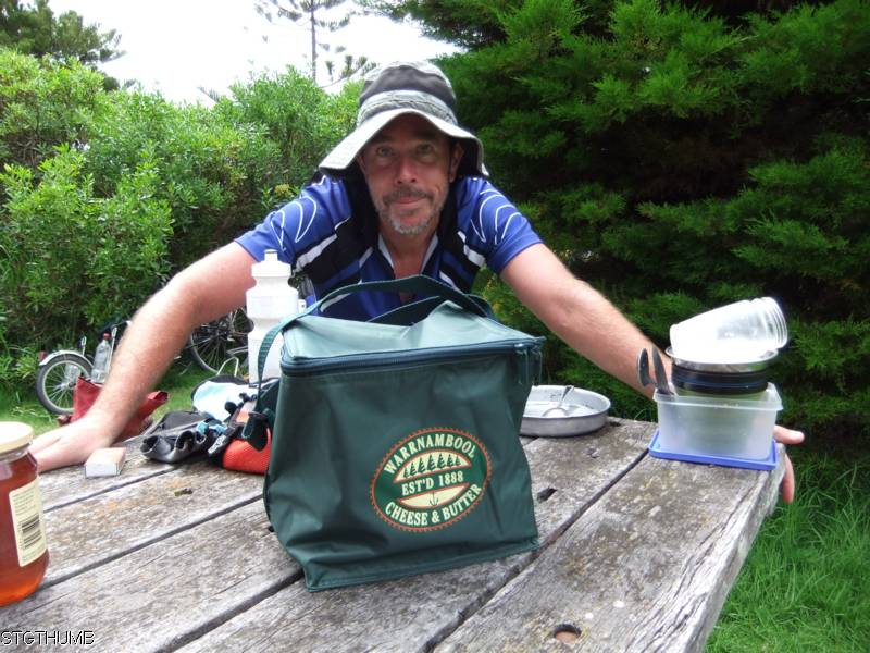
Anthony who works at the Warrnambool cheese and butter company kindly gave a cooler bag to us - and this is the perfect size for my panniers and is a bit bigger than the one that got stolen at Barcaldine last year! thanks Anthony!
We have been to Port Fairy before but one thing I don't remember is the mossies - they are thick and viscious so we have to spray ourselves regularly with aeroguard and even then they still continue to bite through the clothing.
We went for a walk this afternoon and remember how last year we took a photo of every street that had our names ... well we found another Kouta one but again they got the spelling wrong!

We went down to the estuary and sat on the banks watching 2 guys fish (they didn't seem to be successful only in pulling in plankton ... beached az bro!). But we did manage to capture a family moment...

Tonight we will walk back to here and I will go across to Griffiths island to the mutton bird viewing platform (it is a national park so Kouta is not allowed) hoping to see them come in en masse around dusk.
We are staying here tomorrow - the campground is big and not very full but has a camp kitchen with bbq, fridge, hot water urn, gas burner and toaster. It is still expensive - tonight is $33 (peak) for unpowered and tomorrow is $30 (shoulder). Dad if you are coming this way you might want to consider bypassing Port Fairy and continuing onto Yambuk which is alot cheaper nothing there but a campground but the kitchen facilities at this campground is surprisingly good!

Sunday, January 30, 2011

Peterborough to Warrnambool


Peterborough to Warrnambool = 53km
Cummulative total = 152km
It was a long hot and exhausting day for us all today - I didn't think we were going to make it!
Knowing that Heather and Anthony were going out this afternoon we decided to get up early and make an early start and fearing that we might sleep in I had a very broken sleep because I was petrified that I was going to oversleep! Anyway we woke up in good time! but first some more pictures of the beautifull victorian coast line.

a blue wren

those houses have a very nice view!
So we were off and the wind was already up as well and was coming from the North west so it was a head wind the whole way to Warrnambool.
We were the only ones on the road this morning but after about an hour the traffic began to pick up. Just up the road from Peterborough is Bay of Martyrs.
I think they are just a collection of rocks that have broken off the mainland. And a few kms further up the road is the Bay of Islands

This was taken from the road and it is a popular boat launching place.
From here we cycled along the Great Ocean Road to Nirranda where we stopped for a quick break, topped up our water bottles as although it was only 9am it was becoming very hot. the wind was blowing harder than when we first started out and the going was slow.
Check out the weather vane at the Nirranda netball courts!

It is quite neat and it was definitely blowing from the North west when we took this photo.
Just 2km further along the road there is a cross roads and the GOR turns right but we continued on straight and took the quieter road. This was a good choice as the GOR can get busy. The road is a little bit rolling and funny enough a few years ago we came this way from Warrnambool to Port Campbell and it seem flat (maybe because we had a raging tailwind then!) but now it seem a little rolling! (maybe because we have a raging headwind!). The road then links up with the GOR again and you go along for 3km and then we took a dirt road left (Carrolls lane) to avoid going into Allansford and back out again to the Hopskin river road. Not long this road there is a shady spot under some pine trees which made a great lunch spot.
by now the temperature is very hot indeed and all our water is almost hot and very unpleasant to drink! Just as we were packing up we saw in the distant 2 cyclists so we waited for them and it was father and son out touring - they were from Melbourne so I assume they are going back - today they are making for Port Campbell.

this is the dirt road we were on - only about 3km worth but it saved us at least 5km! This road joins up with the Hopskins River road and we have cycled this road a few times and there is always a headwind! Once we got to the bridge that goes across the river we had to pull over and get some coco cola into us as we were a bit weary at this stage and poor kouta was desperate for cool water and wouldn't drink the water out of our bottles as it was too hot for him - so while Neil was looking for a tap Kouta had found a ground water tap that was leaking and decided to drink the water around it! Normally I don't like coca cola but it sure went down well today.
We still had to go on the outskirts of Warrnambool to get to Heather and Anthonys home and it is a slight climb to there place and I tell you we were glad we finally got here - very weary from the heat and headwind!
Tomorrow we go to Port Fairy and hopefully we will get to see the mutton birds come in at night. We will stay there 2 nights and we will take turns at going to see the mutton birds coming in around 9pm as I am sure they won't allow kouta to view as well!

Friday, January 28, 2011

Cobden to Peterborough


Cobden to Peterborough = 48km
Cummulative total = 99km
Slept like logs last night with only one interruption from Kouta wanting to get out at 3am in the morning thinking that there is something more interesting than sleep out side the tent!
Otherwise this morning we woke a little stiff but once we started moving about we loosened up pretty quickly.
Picked up food supplies from the IGA at Cobden as wasn't sure how big Timboon was or if it had a supermarket and since we were going to Peterborough and we know they definitely don't have a supermarket only a milk bar and pub! so we picked up 2 days worth of food as we will stay an extra day at Peterborough.
The ride to Timboon was hilly - in fact there are 3 hills, the first is just after the turn off to Jancourt and you go down to Curdies river and then there is a climb back up only to go back down to some small creek. Now the climb back out of the creek is quite hard - it is never ending (probably only about 1km but it sure felt like 10km!!!) and I was at the limits of my gears and muscle strength! We made it to the top and then there is a nice downhill to the intersection where you meet up with C164

at this intersection we had a quick break and I noticed just how green the area is considering it is the end of January normally this area would be brown and the dams empty! As you can see from the photo above it is really green.
From this intersection there is a gentle downhill to Scotts creek and the a gradual climb to the top before Timboon and then a downhill into the actual town of Timboon

It was an okay ride from Cobden to Timboon and the legs coped okay with the hills so maybe we haven't lost too much of our fitness from last years tour!
The town of Timboon is bigger than what we thought - as the sign above says it is the first country town in Victoria to adopt a no plastic bag policy. The town has a pretty good IGA supermarket (so we didn't have to get supplies at Cobden!), a bank, pharmacy, butcher and hardware store. The one thing it doesn't have is a caravan park, but where we took our break there was a sign saying there a proposal for a caravan park.
From Timboon there is a nice gradual climb out for around 4km and at the turnoff at Cowleys creek the road levels out a bit and then an ever so slight down hill to the coast with the odd bump here and there.
The road is relatively quiet and used mainly by locals as it is only 1 & 1/2 cars wide up to Paaratte and from there it becomes 2 lanes. This road joins up with the Great Ocean Road 2 km before Peterborough.
the photo below was taken on the bridge just before you get to Peterborough - it is at the mouth of the Curdies river with the ocean.

The campground is on the left and backs onto the inlet so there is calm water although the water is very brown coming down the curdies river - we are assuming it is from the tannin (spelling?) from the flooded rivers.
The campground is a top tourist and we are still in peak season so we paid (with our 10% discount) $30.60 for an unpowered site. The unpowered section is tucked away at the back and there are not too many here the first site they put us on someone was already on it so Neil went back and then they put us on site #9 which is in the corner and great for us with Kouta. there are quite a few permanent holiday makers in this park. In fact the whole town is made up of holiday homes as you don't seem to see anyone in the actual houses! It has great facilities - full kitchen and bbqs, damn hot showers and the sites are all well defined!
Went for a walk to the look out which is in town and only around 200m from the campground (couldn't go along the beach as dogs are not allowed on the beach during this time until easter during 9am to 6pm). Great views from the lookout especially looking east wards along the rugged coast line.

and a close up of the point
below the lookout is an out crop of rocks and I reckon the one on the left has the best campsite which is currently being taken up by a Shag!


and below looks back towards inland at the inlet where the Curdies river meets the ocean.

Having a rest day here tomorrow and will go on the other side of the inlet to see if we can let Kouta run there as there doesn't seem to be any one around on that side.
I did forget to mention last night when I wrote the blog that as I was cycling along thinking about my blackberries and thinking what I am going to put them in when I pick them and I thought now what did I put them in last year? that's right my collapsible bowls .... OMG I didn't bring the collapsible bowls! ... what the hell are we going to eat out off!!! I yelled back to Neil telling him I forgot to put the bowls in the bags, in fact I clean forgot all about them! Lucky we have 2 cooking bowls which are now doubling up as our cereal bowls! I might try and look for something in Warrnambool!

Thursday, January 27, 2011

Colac to Cobden


Colac to Cobden = 51kmm
Cummulative total = 51km
We're baaaaaaaaack!!! Yikes we are at it again after a 3 month break and boy we could tell today that we have had a break! As you can see from the above 2 images we have sort of restyled - if you want to have a closer look at the profile or map just click on the image and it will enlarge but to return to this blog you must click the BACK button and not the red 'x' button!
Anyway we drove to Colac yester (Australia day) and headed off this morning at a leisurely 9am departure.
Below are photos of the bikes loaded up including Kouta waiting in the trailer for us!

Neils bike

my bike with Kouta.
Kouta slipped back into the routine quite easily and this morning he hung around our feet just to remind us that he is coming along with us ... he has a fear of being left behind! It was okay going along the main highway and there was not much wind about but you could feel it building up from the west. The legs felt a little tight going to Swan Marsh ... I suppose it was just getting use to pushing the heavy weight of the bikes.
We turned off at Pirron Yallock and it is a nice quiet road from here to Swan Marsh, where we chatted to a local and we noticed that the tennis courts had been tidied up a bit and we pointed that out to him and he mentions that the town (only a few houses there!) is getting a new fire station and the local primary school only has 5 students ... no over crowding in the class there!
We came through this way nearly a year ago - only 1 1/2 weeks earlier compared to last year and the one thing I noticed was that the blackberries were still green so no blackberry picking up near Carpendiet for us today.
We got to Carpendiet just on lunchtime and the legs were beginning to get a wee bit weary! the wind had picked up and it was a strong headwind which was okay as long as we didn't think about it!


We have a cuppa at this rest stop quite a few times now so there was no need to take too many photos as coming along here it was a sense of 'de ja vue'!!! But I couldn't resist just taking one photo of Neil in his new $5.19 markdown Aldi cycling shirt!

Also just across from the Capendiet hall is a farm house that has a few yaks ... not sure what they are used for (maybe milk?)

Really I only took this photo so I could play with the camera by taking a far off shot and cropping it in closer on the computer.
Just past Carpendiet hall is my blackberry picking spot and some farmer had killed all the bushes on his farm edge and Neil mentioned that last time we came here we came across an Echidna and he wondered if we would see it again ... I thought he was joking ... but a few kms later we saw one!

not sure if it is the same one though ... and like me I think he was looking for blackberries. Just before you turn the corner of this long straight road there were still some bushes but the blackberries were just too green. Looks like we will have to finish off the diabetic fruit cake Flo had made - mind you as I write this blog I have already had 2 slices and the fruit has given me wind ... so the fart angel only knows what it has given Neil!
After Carpendiet we start to get into a few rolling hills to Cobden so basically it goes like this - along, down, up, down to meet with the road that comes from Stoneyford and from here the traffic increases a bit as the traffic is being diverted from the main highway via Cobden to get to Warrnambool as there is a bridge further on that has been damaged in the flood. So the traffic wasn't that heavy and the road has been repaired a bit (to cope with the traffic load!) so the cars had to go slower. After joining the road you start to climb a bit then go down again only to go up one more small climb just before getting to Cobden - any other day after the long tour last year the hills would have been okay but since this is the first day out the hills were a wee bit hard!
But we both pulled up okay and after walking into town to get some food the legs feel okay.
While walking into town from the caravan park you cross where they have dammed up the Cobden creek which is nice and full and on the opposite side of the road is the local pool and then after that I think they release the water to continue on as the Cobden creek.

It is a nice setting around the creek in fact the whole town is quite nice.
When Neil went to check in at the caravan park, Neil mentioned that we were here last year around this time and the guy didn't remember us until mentioned that we camped in the corner and had the snake near us ... then the guy remembered us! But no snakes today! or fighting girls like last time!
Off to Peterborough tomorrow and we probably stay there on Saturday. Hopefully we can go for a swim!