October cycle tour map

October cycle tour map

Pages

Thursday, October 18, 2012

LOCK TO ELLISTON


LOCK TO ELLISTON = 92km
CUMMULATIVE TOTAL = 1181km
WATERLOO CARAVAN PARK = $25.20 with discount (powered)
 
Well as you can see from our final destination today (Elliston) we are not in the place we were suppose to be in!  Our plan was to travel north to Highway A1 and to a place called Wuddina (pronounced wood-na ...don't ask we keep getting corrected as we pronounce it Wud-dina) but we found out last night that the caravan park which is also a conference and motel doesn't take dogs and on their website they highlight the fact that they have a 'strictly no dogs' policy. Soooooo we had to change our plans and after many a discussion we decided to flag Streaky Bay and go across west to Elliston and join the coast there so we miss the part from Streaky Bay to Elliston. It is quite annoying that some piddly little obscure town on the main highway won't take dogs.  We did look at alternatives but that would make that day too long or the next day too long and the rest area was too close to the road and no toilets (it would have been better of the road and no toilets) and with the weather tipping to be above 30 degrees we sort of didn't want too longer day trying to find somewhere to camp alongside the road.  So here we are at Elliston!
We did get up before light (it gets light here quite late in the morning around 6.30am before you can see things properly) so we managed to get away before 8am.  The wind was suppose to be a east-north-east and around 15km per hour so that would help us with the long day ahead (90km) but when we started there was no wind and it was overcast and chully!
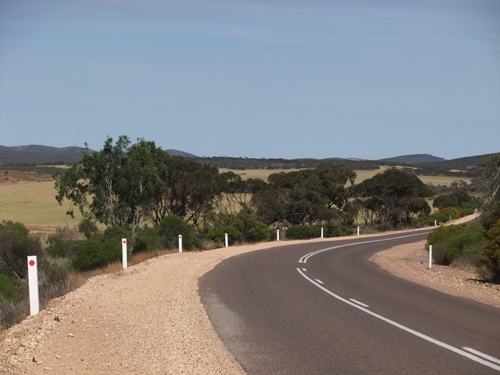
It was lovely riding on that Birdseye highway no cars!  We did come across some grain fields and even the canola was cut and drying out ...


our road is relatively flat but there were a few undulations, the road itself was also lumpy and bumpy which was strange compared to the previous 2 cycle days the road surface was ideal for bikes ... they shoud rename this highway as the 'cycle highway' as it is a dream to ride on!


we were cycling along quite nicely and making good time, we decided to break the ride into 20km lots and to have a cuppa at 40km.  We found a sub station at the right moment for our cuppa and used the self timer to take this family portrait ... the first photo taken Kouta had his backside to the camera ha typical!


a special moment between Neil and Kouta ...


As we get further away from Lock the grain fields become less and less and there is more empty lands dotted with the odd herd of sheep or cattle, but most of it was empty.  In the distance we could always see the 'Ayers Rock' of the Eyre Peninsula - Mt Wedge - nice to see they really thought long and hard for the name for this monolith!


and as we got closer you could see that there were more grain fields at the base of it.  It is about the 60km mark that we encountered another touring cyclist - an elderly guy riding a Bike Friday and towing a 2 wheeled trailer, he was British but lives in Sydney and was cycling from Esperance to Adelaide via the Nullabour plain - he said he has had nothing but headwinds - he started in September about the same time as us


At 60km we took another break - the legs were still okay but we beginning to feel it.  The road was more undulating now but still ridable.
Sometimes we come across some interesting looking letterboxes - like converted fridges, microwaves, tree stumps etc but this one is probably the best so far...
great use of a small model aeroplane! 
By now at the 70km mark the sun is beating down on us and all around us are fields of rocks ... we are not sure if they are farming them or there is too many of them to clear and farm the land!

When we started the day out we didn't think that it would reach 30 degrees but by lunchtime it was warm and about 7km from Elliston you have to go up a 3km steady climb and I tell you it was hard to do after already doing 85km! and it was hot by then but once at the top you got an amazing view of the ocean and Waterloo bay ...
 
We finally arrived at 2.30pm which wasn't too bad and it was hot now around 34 degrees so it was great to set up camp and with the shade cloth as we are exposed to the afternoon sun. Not alot of people here at the moment but they expect a full camp on Saturday.  Nice campground they have a good camp kitchen and free bbq - going to eat fresh food for dinner!
Elliston is very small and the local IGA is small and really expensive but what we sort of expect in these small towns that we stay in.
We are staying here 3 nights as Neil doesn't want to ride on Saturdays as we are finding that that is a very heavy traffic day anywhere!

Wednesday, October 17, 2012

YELDULKNIE WEIR TO LOCK


YELDULKNIE WEIR TO LOCK = 80km
CUMMULATIVE TOTAL = 1089km
LOCK CARAVAN PARK = $20 (powered) $12 (unpowered)
 
We had a rest day at Yeldulknie Weir ... that means my last shower was on Sunday afternoon and it is now Wednesday afternoon :) ... it felt good to get a hot shower at  -Lock.  Here are some photos from Yeldulknie Weir ...
neil on the wall -


as you can see there is not alot of water in it, I don't think it is still used by it use to supply Arno Bay with water -


Our camp spot amongst the shade of the trees -
enjoying a cuppa - you will notice that I am wearing a fly net as the flies a quite annoying here on the Eyre Peninsula - 


It was a good rest day and we needed it. So today we tried to get up early as we knew we were going to have a long day and although they forecasted it to be east-south-east winds which is a tailwind to us I always believe that you should alsways listen to the weather report with a grain of salt ... in other words (like Dad says) 'expect the worst and you won't be disappointed' LOL
We did managed to leave by 8.30am and by then the wind was blowing from the East and woop peeeee we had a good tailwind.  We stopped in Cleve to go to the bank and continued on - as you can see it was a gradual downhill to Rudall so the average at that point was around 20km per hour (at this rate we would get to Lock in 4 hours!)
From Rudall it flattens out and the wind still is blowing behind us and I cannot believe our luck with this.  It is very dry over here but the crops are growing - the canola fields have been cut and are in their wind channels drying out even more and will soon be processed.  The grain fields are turning yellow and the small towns are getting ready for the harvest possibly within the month I think ... hence why there is no real traffic on the roads but come harvest time the roads will be chockers with grain trucks I think ... we should be gone by then!  So here is the typical view for today ...
Didn't see any snakes today but a few and various lizards - Neil stopped to take a photo of one ...
Still the wind is blowing behind us and we were still riding along at about 20-22km per hour and by the last 10km the legs felt like they hadn't cycled but there was a gradual rise coming into Lock and the legs sort of felt it then!  Lock is a grain town and doesn't consist of much - the campground is overpriced at $22 for a powered site (they charged us $20 since we don't have a caravan!) or $12 for powered (which is reasonable for unpowered) the town as an IGA, post office and pub and that is about it - lots of big silos for grain.
Here is our tent spot amongst the trees for shelter - about 23 degrees today but tomorrow I think it will be warmer at around 30 degrees.
Tomorrow we head north to Wuddina I think and then the next day along the main highway to Poochera and then the next day to Streaky Bay and then back to Melbourne!

COWELL TO YELDULKNIE WEIR


COWELL TO YELDULKNIE WEIR = 42km
CUMMULATIVE TOTAL = 1009km
YELDULKNIE WEIR PICNIC AREA =  free (unpowered)

We had a very eventful day today … one to get the ‘dicky ticker’ going!  But first we had a very windy and wild night last night – the strong northerly wind from yesterday (which produced a temperature of around 34 degrees) died down early in the evening and then at some point during the night (not sure on the time) it blew like mad – the tent was rattling and a shaking like anything – I woke up, heard the wind and the rolled over and went back to sleep.  Neil said he got up at one point as he thought the wind had knocked the bikes over … I didn’t hear that!
So this morning we left around 8.30am and expecting a tough day with more headwinds.  We stopped of at the IGA in Cowell to pick up bread and while waiting there I thought this is a really nicely presented town center, very clean and the buildings are well kept.  I would imagine this would be a busy place in the holidays.
So we started out and knew we had to get over the range and basically you start climbing from the town center up until 18km later where you sort of reach the top.  It is a very gentle climb along the Lincoln highway and then we turned off at around 10km and onto the Birdseye highway and you climb more there – but it is okay climbing not like out of Port Wakefield over on the Yorke peninsula.  This Birdseye highway is very quiet – hardly any traffic so perfect for us … not sure if it would be busier on the weekends?  At 15km we took a break at the May Gibbs memorial.  At first I didn’t know who she was but once I read the plaque I recognised the name.  She wrot e the baby gumnut books – apparently she lived around here when she was born.

The view from here back on to the bay is not bad but there is nowhere along this hillside that gives a great view and even from the top – everything is blocked off by either a tree or a damn hill!
As you can see it is a gentle climb up through the hills in the range

Once over the bulk of the range you start to go down and you go into a valley of a mixture of fields and rock fields!  You also get a good view of Mt Millar wind farm and they are on your right as you come down … I love windmills they are far more scenic than damn power pylons!

Along the sort of valley you flatten out a bit but not before long that you start gently climbing
At this point I am so relieved that I put my fly net on just as we got onto the Birdseye highway and they were pretty thick … little pesky ones but at least there wasn’t much wind if anything it didn’t really pick up until midday and we were nearly at our destination by then … we are so lucky sometimes!
At about the 34km mark we were flying down a lovely 2.5km dead straight hill and we passed the 1000km mark and this was marked by a stumpy tail lizard on my left, a dead snake in the middle of the road and a blue tongue lizard on my right further down the hill!
The turn off for Yeldulknie Weir is about 5km before Cleve and is a 1.5km dirt road to the picnic area.  The first thing I thought of is that we must be careful of snakes around here as although it has  damn wall and there is only a little bit of water behind it it still will be a haven for snakes.
It is a lovely spot and there was one other travellar here when we got here just after lunchtime.  We had a cuppa and I went for a walk up the path to have a look at the damn to see if we could swim in it … along the way I saw something lying in the middle of the path … at first I thought it was a little skink or lizard but I couldn’t see any legs and upon a closer look it was a baby snake about 1m from me, so I waited debating whether or not to step over it or go back … but it decided for the 2 of us and moved on … feeling reluctant to go on but the need for a dip in the water was stronger so I continued on cautiously.  But I couldn’t see any path down to the water and I most definitely wasn’t going to walk in the grass.  So I turned around and came back and said to Neil I will have to wash in front of the tent.
So we set up tent in the shade of the trees – while we are doing this Kouta has found a lizard and is amused by it, mind you I was extremely amused by him watching it in the first photo and then try and get at it in the following 2 photos!


it is hot about late 20’s and we had just finished and I was about to set up to have a wash – Kouta was sleeping in the tent, I was standing outside the tent door faffing about and Neil was on the side of the tent and then all of a sudden Neil yells out snake, get out of the tent Janet and Kouta – so I immediately went to where he was and we both called Kouta who staggered out of the tent and came to us (he must have sensed the urgency in Neils voice) and I picked him up and said to Neil where is it and at that point I saw it pass the tent door heading away from the tent and it was a damn long thing!  I tell you it was endless, my jaw just dropped when I saw that it kept coming!
Meanwhile our neighbour came over and was watching it as well calling his dog back and he said that must be what his dog was growling for before as the snake came from his direction and slid by our tent (about 50cm from it) and continued on across the road, down the embankment and crossed the other road and then gone.  It was right up alongside the tent and past the front door of the tent ...

As you can see it was very long and the guy identified it as a Taipan (deadly!) and they both guessed around 5ft.  Probably the closest I have been to a snake that big – I tell you it was awesome to see as it just merrily went on its’ way determined to get somewhere but not near us.
What struck me as odd was how close it was and the fact that it chose a path that came so closeby the tent and near us but was not interested in us at all.  So now we are on the lookout!
Later on in the afternoon we saw a car come down the road and just out of view I heared it stop with a skid and I joked to Neil that they just stopped for a snake and funny enough when they set up tent and Neil went up to them to warn them that we had a snake earlier on and to be careful – they told him that they saw one cross the road and that was when the stopped!  LOL
Here is a closer look at the snake ... I love digital photographs!


Crikey I still cannot believe how close it was to the tent I can see it’s indentation in the dirt from where I am typing this as it came from the back of the tent and along the side … and I think whew lucky he didn’t decide to come by when I was having a wash otherwise I would have had to evacuate half dressed ha ha ha!

Sunday, October 14, 2012

WALLAROO TO COWELL


 WALLAROO & LUCKY BAY TO COWELL = 19km
CUMMULATIVE TOTAL = 966km
HARBOURSIDE CARAVAN PARK = $25 (powered)
 
Before I begin on our ferry trip over - yes if you look at the map I put the ferry crossing on the map although I don't know how far across in distance it is!
But first I thought I would share with you something and then show you a few photos from last night ... Last night while doing the blog in the kitchen one of the campers came in and offered me half a potato salad and a lettuce salad - he said that he was going to throw it away as the kids won't eat it but thought he would offer it to me first (I think he saw us come in on the bikes and felt sorry for us!) so that was lovely to eat with Abbots bread mmmmmm! now for the photos ... the first is Kouta walking along the beach at sunset and there is a guy there flying a remote controlled aeroplane and so it produced a buzzing noise that was driving kouta nuts as he couldn't figure out where the noise was ... eventually he worked it out and was following it everywhere it was like he got second wind and was chasing it!


The next is off the sunset ...
it was a good night temperature wise and we got to have a little sleep in as our ferry didn't leave until 12 midday, since check out was at 10am we got to the terminal a little early ... on our way I thought I would show you the state of some of the streets around here (remember how I was complaining about them last night!) ...
 and another ...
here are some photos of the Wallaroo ferry - 
this is the front and they had to take it out and then reverse it back in ... the problem they had when getting it back in (rear end first) is that the wind had really picked up and it kept pushing it across towards the rocks ... but really it doesn't have much room to manouver (spelling?) between the poles ...


and the cars start to load on and then the passengers and us on bikes ...
Once we let kouta out of his trailer he just thought "what the hell are we doing now ... I'm too old for this"  LOL - he thought all the noises were strange but once we got him upstairs and under cover and in his basket he was fine ...
mind you he longingly looked in that doorway there knowing that was the 'inside' but we were not allowed in there with him! so we stayed outside mainly on the stairwell as it was protected from the strong northerly wind - I tell you that was blowing and as we got closer to Lucky bay it was a bit like being on a pushbike into a headwind ... it just got slower and slower and I think it got in about 20mins late!
This is the view from the boat of Wallaroo...
 
While at see we did see a big grain tanker (at least I think it was one) and that probably came from Whyalla
Kouta slept for most of the way whereas I sort of felt a bit sick especially out in the sea - Neil said the sea was calm but every now and then the boat would rock quite a bit - you couldn't walk straight without having to hang on to something so I assume his assumption that the sea was calm is WRONG!
So Mum I think I may have your gene of sea sickness - but I did go to the top deck and that felt a little better - I think where we had Kouta at the back of the ferry you really felt the ferry roll - once on top it wasn't so bad and I did lie down on the stainless steel benches and that felt even more better!
Once on land we had to ride about 14km to the caravan park - straight into a head wind and boy was it hot ... 4 days ago we were freezing and today it is hot with very strong winds blowing and that will be the same tomorrow.  We will continue to some Weir just before Cleve and if it is nice will stop for a rest day there.


Saturday, October 13, 2012

PORT WAKEFIELD TO WALLAROO


PORT WAKEFIELD TO WALLAROO = 67km
CUMMULATIVE TOTAL = 957km
NORTH BEACH CARAVAN PARK = $22.50 (with discount) unpowered
 
As you can see from the map we crossed the top of the Yorke Peninsula and are here at Wallaroo, we are hoping to take the ferry tomorrow to Lucky Bay on the Eyre Peninsula.  Unfortunately Neil forgot to find out where exactly on the Ferry the dog has to go - generally they stay in the car but whether they will accept him staying in the trailer where all the cars go and us staying with him we don't know and can't find out as the ticketing doesn't open until 1 hour before departure.  Departure is at 12 midday on Sunday so we will go there at 11am and if we can't stay with him then we will probably continue on around the Yorke Peninsula and skip the Eyre Peninsula.
There was hardly a breathe of wind today so cycling was a little easier for the bulk of the day - if anything there was an ever so gentle easterly pushing us along but not up the first hill just before Kulpara - it was a munter of a sooty grunter!


The range is innocent enough but the choice of where the road should go is not as they always find the steepest part of the hill and build the road up that!
The view about 2/3 of the way up is good but nowhere to stop along the side of the road so we waited until we got to the top ...
As you can see this is the top of the Gulf of Vincent and after waundering around Port Wakefield las night it tends to be mangroves and tidal.  I tell you Port Wakefield has 2 faces - the first near the caravan park which is the old part and is full of batches worse than what we had on Waiheke!  They are a miss match of tin, asbestos sheets and are about 1cm apart from each other.  I tell you bits and pieces are just tacked on to make another room, or the garage is converted into some sort of living space ... it was unreal and then this morning as we came along the A1 on the left are huge new housing developments!  The town on the main highway has 4 gas stations - 3 going to Adelaide and 1 going north, it also has 3 bakeries/cafes ... it is unbelievable!
So once you go up the 5km hill before Kulpara you have a nice gentle 5km downhill and then it undulates a bit but mainly in a downhill direction so the going was easy - at times we were on our biggest chain ring comfortably (must be getting stronger)
At Paskeville we had a cuppa and then continued on to Kadina where we picked up alot of supplies and then onto Wallaroo which is a further 8km on.
The road along here is fabulous from Port Wakefield to Kulpara and then it ends - it becomes a narrow road with not much shoulder and there can be huge patches along the road.  But that is not the worst of it ... that occurs once you get to Wallaroo - a bigger place than what I thought it would be ... clearly a holiday destination with huge houses backing on to a marina and who are clearly not paying enough rates as the roads are atrocious - they are probably the original roads from 1950's - I kid you not!  There are more potholes and patches in this town than the entire Australian road system, honestly I saw nothing of the town as all I could do was look at the road in front of my tyres to make sure I don't disappear down a pothole!
Anyway we tried the caravan park right next door to the ferry but that was full (only 18 sites available and the rest are cabins) so we had to come to the top tourist which is on 100m or so from the ferry terminal as the crow flies but about 3.5km by road as you have to go around the entire marina which has some lovely houses and quite are few are rental homes and are empty!  who said Australia was heading towards a depression!
So at the top tourist park we got an unpowered as the powered is really expensive - it has a camp kitchen which has bbqs, fridge, toaster and kettle so it is not bad.
Went for a walk along the beach as the tide is out and it is lovely here ... it would be an absolute dump at christmas holidays as it would be really over crowded and any place that is crowded is a dump!
Near the ferry terminal they have the grain silos and I think by the looks of it in this photo there is a long hose that goes to the wharf and I assume they fill the ship up with grain?
here is a close up of the silos and the red roof at the bottom is where we catch the ferry tomorrow ...


here is some more photos of the bay ...

and this is the campground ... the front units are part of the park and the caravans on the right are $31 powered per night for the beach view! 
Not sure when we will be having a rest day - it depends on how we go with the ferry.