October cycle tour map

October cycle tour map

Pages

Saturday, March 23, 2013

Bendigo to Laanecoorie to Bealiba Reservoir


Bendigo to Laanecoorie = 50km
Cummulative total = 50km
Morning temperature = 10 degrees, todays high is 21 degrees (feels like 15!)


Laanecoorie to Bealiba Reservoir = 43km
Cummulative total = 93km
Morning temperature = 9 degrees, Day high temperature is 24 degrees (feels like 15 again due to the wind)
 
Well we are back on the road again and this time leaving from Bendigo.  We drove up on a very wet and windy Thursday but by Friday morning it had all subsided to be a chilly day.
Left at around 8am and joined the bike path from Epsom to the City to the lotus leaf ...
from there we joined the road and headed out to Kangaroo flat and turned onto the road that takes you to Maryborough.  This road is okay and last time we came in this way it was a hot day and the road was very busy with traffic coming from Maryborough to Bendigo.  But today we were going the opposite way and the trafftic both ways was minimal!
You have a short climb from Aldi of around 2.5km and then it is down and along.  No real shoulder to speak off but enough room for you to duck in when a car overtakes you.
Once at Lockwood you cross over the highway and it is flat with a little up and down.  Our coffee break was at Shelbourne east ...
 this was at the 27km mark and Neil and I both felt okay but poor kouta ... he was knackered already!
from here it is a little bit down but you still have to pedal, very little wind and if anything it is coming from the west so a slight headwind.  At albout Shelbourne the road becomes straighter and flatter and Laanecoorie is only another 11km away.
Kouta was over the moon for us to arrive at the free campsite alongside the Loddon River and by the time we got there around 1pm there were plenty of vans already there.  So we chose our spot on the grass ...
 a lovely spot too with a view of the river and enough room for a van to fit but only if they go length ways ... but off course within 1 hour someone has arrived and parks across and unbeknownst to them blocks the road for the boat traffic to get to where they launch (he found this out a few ours later once he set up and a scout group comes and informs him his van is across the road for them to get their kayaks down to launch!) so he comes over to us to see if we are leaving tomorrow and we are so he will move his van then ... I think he did think about asking us to move the tent and then he can move his van a bit ... neil would have said to move his van on the other side of us!
Anyway we had a lovely spot and the scout group turned up after 6pm so there is at least 50 people here!  The usual crowd of dominating caravans that use and dominate the one and only tap (we find one up by the tennis courts that has better and clearer water!) and unfortunately there are only 2 womens toilets of which there is no toilet paper and the cheek of it all the council would like a donation - not fresh water and no toilet paper = no donation!!!  as you can see from the photo below it is quite crowded ...
 generally where there is a free public camping area there are always some rowdy people and this place was no exception ... and I know as you read this you ALL groan and think on no what has Janet done this time ... well NOTHING!
Expecting some noise and music until late I bit my tongue and fell asleep at 8pm only to be woken up by 2 lots of music at around 10pm so I lay away from 10pm until around 1am and during that time I had Bon Jovi in my right ear and some dance music in my left ear.  Thinking out of all the people here surely someone will say something .... still the music and it is loud and then a very feral male voice starts singing the Bon Jovi songs ... crikey I have to say something ... so I listen for voices and I hear voices and I don't like the sound of the feral male (his voice is very much like Jimmy Barnes but more feral due to alcohol and smoking) it is very drunk and agressive ... I decide to not say anything but then again someone did say something because the camp goes quiet and he is on this feral aggressive rampage about being homeless etc (even though he has a nice car and caravan) and his wife is drunk and just as feral but definitely not as aggressive ... so this ranting and raving on about his pitiful like goes for about 1 hour and his Bon Jovi music has ceased but the dance music from the other group is still going loud by they eventually turn off and go to bed ... but the feral is still going on and everyone can hear.   He finally stops at around 1.30am and I fall asleep with one ear perked up waiting for him to restart.
We get up a 7am just as it starts to get light and the poor scout group also rise and go for a walk and as we pack up the feral bastard comes up to us and acts like nothing happens and poor Neil is trying to not encourage him, meanwhile I have bit my tongue right off and trying hard not to put my fist in his mouth! I do succeed and carry on about my business.  meanwhile the nuff nuff neighbour of ours who parks his van across the road to the boat launching has packed up his van and is waiting for us to finish packing.  He and his wife are trying very hard not to tell us to hurry up! (off course I am sure Neil is packing slower) meanwhile yet another load of kayaks have turned up and are waiting to go down to launch their kayaks ... we are loving this, the nuff nuff and his wife are standing waiting and watching us ... finally we leave :)
LOL it was cool morning of around 9 degrees and about 10 degrees when we set off at 9am.
A nice road to Tarnagalla ... although Saturday traffic is horrendous ...
 as you can see it was peak hour for us.  You have a very slight gradual climb up to Tarnagalla, the road is quiet and the only traffic came from the 40 odd Kangaroos that bounded across the road in front of us - that kept Kouta entertained for around 1km ... he loved it watching them alongside the fields and then up and over the fences, across the road and then up and over more fences.
At Tarnagalla we joined the Wimmera highway to Moliagul.  From Tarnagalla you climb a little more and then what looked like a nice down hill turned into a bad one - you have to stop at the bottom to cross a railroad crossing! 
By now the wind has picked up and is a strong westerly and since we are going west it is a headwind.  The road to Moliagul is a gradual climb and has fields either side so the wind dropped us down to a slow pace.  No shoulder on this road but today there was very little traffic.
We stopped for a coffee at Moliagul.  It is a small rest area and has 3 vans there (all gold prospectors) one is there and chats to us. 
We leave Moliagul and rejoin the Wimmera highway for about 1km and then turn left onto the Bealiba road which climbs a little more and then down basically (a nice down hill too!)  It is about 11km to Bealiba where we pick up water and continue south to Bealiba Reservoir.  It is 3km further and of that 3km about 2.5km is unsealed, a little rough in places.  Relieved to get here and are rewarded with a lovely spot and no one around except for a walking group on the opposite side of the dam who eventually move on, then a few locals come for a fish and just when we think at 4pm that we have this place to ourselves and no feral Jimmy Barnes sounding nuff nuffs ... a damn huge mobile home turns up not far from us (I am cursing now) but lucky for us they decide to move to the other side of the damn opposite us!  So I am happy now ... we will get some sleep ... here is our pristine spot ...
 and neil enjoying the serenity ...
This place has no drinking water and only a pit toilet but it is a very quiet spot and not sure if many people come here.
Tomorrow we make for St Arnaud.

Sunday, December 16, 2012

Fence building:)

Here are some photos of us building a fence between us and our neighbour ... this was suppose to be done next weekend but one of the neighbours dogs kept breaking down the existing rotting out fence and coming over for company!
First chore was to clear away the existing fence and dig holes - very hard when trees are close by.  Then notching out the fence posts - which was left to me since I have a natural and genetic ability to carve!


Zowie taking a break!


next came to set the poles in concrete - 6 poles = 6 bags of cement = 3 for Neil and 3 for Me!
We were up early the next morning - another hot day and we put the cross rails up once they were up it was easy going with the palings


once they were up for the entire length (12m) of the fence we could stop (it was around 3pm and we were exhausted - been a long time since we have done a 8 hour day of work - cycling doesn't count!) and take Zowie and Dexter home.

next morning we were up and it was a short job to put the remaining palings - off which I hammered most of them while Neil did the placing and lining them up squarely.  Once all were up we went back through and hammered the remaining 4 nails in each paling.


Neil happy with his fence!

by mid morning we were finished and comparing injuries ... me with a blister on my hand from hammering ...

and Neil with his bruise from the crow bar ...

Tuesday, December 4, 2012

WARBURTON TO BAYSWATER

WARBURTON TO BAYSWATER via Warburton Rail Trail = 50km
TOTAL FOR THIS TRIP = 3249km

Crikey it is damn freezing here in Melbourne - I would be surprised if it even got to 15 degrees today - funny how 5 days ago we were in Bendigo with 40 degrees!
It was a good call to continue down to Warburton yesterday as it did end up raining at some point during the night and throughout the day we had showers and some of them was heavy.
It was a nice ride along the rail trail which we left at Mt Evelyn and joined the horrific traffic along Canterbury Rd - we only 10km along the busy road before we joined the bike path that runs at the back of home.
We got home just on lunchtime and the grass is long and the house is still in one piece!  We are very happy to be home and Kouta is tucked in the corner of the couch - 'his spot'.
Will resume cycle touring after easter 2013.

ALEXANDRA TO WARBURTON


ALEXANDRA TO WARBURTON = 81km
CUMMULATIVE TOTAL = 3199
WARBURTON CARAVAN PARK = $26 unpowered
It was yet another long day today – the bodies felt a little weary this morning after a reasonable nights sleep.  The legs felt good but the neck and shoulders were a little stiff from yesterday on the unsealed rail trail.  Due to the uneveness of the trail you tend to really feel it in the neck and shoulders the next day from all the movement of the bike and trying to keep it under control.  This morning was cool and I am still suffering from Hayfever, according to Neil, most of last night I was snoring as my nose was blocked!  This morning I was no better.  We left just on 8am and headed south on the Maroondah highway.  The section from Alexandra to Taggerty is 18km has no shoulder except for when you go over the hill at Acheron (@10km) this is a munter of a hill but you are rewarded with a great view of the valley going towards Lake Eildon


From here it is down hill, along, up a bit, down a bit, up a bit and then down to Taggerty (which has a Big 4 just as you get into town – doesn’t take dogs though and it sure looked empty as we rode pass!After Taggerty there is a shoulder until Buxton (11km further on) and from there to the turnoff to Warburton there is no shoulder (approx. 14km).  So despite the lack of shoulder for the bulk of the ride along this highway it was okay – a bit hairy in places and you definitely wouldn’t want to be riding this road on the weekends – especially on a Sunday afternoon with people returning to Melbourne.  As you get closer to Narbethong town itself you can see where the fires have been through on Black Saturday but now there is a lot more green undergrowth than what there was when we last past through here 2 years ago.  This is a very scenic highway and would best be suited if there was no cars or trucks on this road!!! LOL
Relieved to get of this road we turned left  on the Marysville turnoff and then a quick right to take the road to Warburton.  Last time we rode this road we had previously stayed at Narbethong caravan park  and so we had relatively fresh legs, but we had previously decided to skip Narbethong and go straight to the top and we were going to bush camp at the top but decided that there was forecasted showers late this afternoon and night and since the last 6km of the up and first 8km of the down hill is gravel we decided that it would be to hard if the road was wet so we decided to continue down to Warburton adding a further 16km to our journey.
This quiet road that goes to Warburton over the Acheron Way follows the Acheron River all the way.  It is a logging route but not much trucks use this and if they do they only probably use the first quarter of this road as there is a bit of damage to the road and then there is none.  It is 21km to the top from the turnoff with the last 6km (approx) being gravel.  The grade is perfect for the bike.  At the bottom of the hill there was a bit of fire damage from Black Saturday but it is very green and lush now


Probably the first 2km of this climb is the steepest and then you just gently climb.  We did stop for a break and a bite to eat as judging by the speeds we were going we weren’t going to get there for afternoon tea.  Now 21km is a long climb despite the gradient. 


I suppose you are wondering why we are sitting on the road – this is a single lane road all the way up and very little traffic on this road if any (all up we had 2 over take us and 2 pass by on their way down – so that is 4 cars in total).
I could have sat there all afternoon but we still had 11km more to climb.  Not long after this break we had to do an emergency stop for our ‘legless’ friend …


We came around the corner and I didn’t see it ahead until Neil said ‘stop’ so I just stopped and then I saw it and was about to ask if it is alive and then it moved.  I sort of wasn’t expecting to see one today as it is cool, if anything I was looking out for them all day yesterday and we saw none!
By now we are starting to get weary and our speed is down to around 11km per hour and then we hit the gravel with about 6km to go to the top and our speeds dropped dramatically as it was a lot more gravelly than what I remembered so it was slow going.  It was difficult to ride along as there were some patches that had heaps of stones and you really had to push through them.  We had to stop a few times for a dring (difficult to ride and drink at the same time when going so slow!)


After a few kms of the gravel the wrists, neck, shoulders and back are starting to ache from trying to keep the heavy bikes under control while going along and through the gravel – the only reason why I put up with this is because this has got to be the most scenic and best hill I have come across in cycling Australia!
At last we reach the top – absolutely exhausted!
 
As much as we thought the 21km winding climb up was tough the down hill to Warburton from here is incredibly tough on the body!  You have 8km of gravel (more gravelly than when you come up) so you are bouncing along and down this is then met with the road that comes down Mt Donna Buang and from here it is 7.5km of sheer steepness – I am sure I don’t have anymore brake pads left.  The decent form Mt Donna Buang is sealed but very winding and in the end at the bottom of the hill when you go to release the brakes completely it is like the wrists and fingers have seized up completely it was very painful to release the brakes!
Happy to be here at Warburton where the price for unpowered has gone up to $26 (plus $1 each for a hot shower) we think it is because it is Dec and the peak rates are now current.  We were entertained by a few of the caravan park locals who gave us a bit of a welcoming party …
 
Tomorrow we take the rail trail home … again!  I have lost count as to how many times we have ridden that rail trail!

Sunday, December 2, 2012

SEYMOUR TO ALEXANDRA

SEYMOUR TO ALEXANDRA = 85km (via Goulburn River High Country Rail Trail - GRHCRT)
ALEXANDRA SHOWGROUNDS =  $25 (powered)
 
It has been a long and very hard day - all 3 of us are very exhausted.  It took us over 6 and 1/2 hours to ride the 85km of which 75km was on the Rail Trail.
My day didn't exactly start great as I woke around 2am with hayfever and didn't really get back to sleep until after 4am only to wake again at 5.30am.  So we got up early and was out of the park around 7.15am.  We rode along the Hume for the first 10km and then took the Tallarook turnoff.  Like with most Rail Trails here in Victoria the start is exceptionally hard to find in a town, for some strange reason the rail trail developers tend to think the only people who will use is will be locals and therefore don't need to put up any signposts anywhere except for some vague street signs pointing in the general direction.  We finally found a rather miserable looking starting sign ...
There a nice introduction to the rail trail and you have a quick short climb out of Tallarook and then a nice down hill to the valley floor.  Heaps of monarch butterflies flutter around you as you ride along as they are sitting along the edge of the path on all the leaf litter … I nearly had to put my fly net on and call it a butterfly net as they kept banging into the face – they are far more pleasant compared to flies!


Great scenery along this trail ...


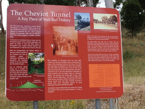
the hill climb from Yea up to Cheviot tunnel (9km from Yea)


looking back in inside the tunnel which is about 201m long


after the tunnel it is down hill to Molesworth -  again the scenery is spectacular
the Goulboun River
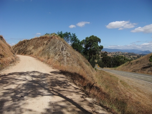
This is the 2nd main climb for the day from the Alexandra turnoff and goes for just over 9km - the road you follow is the one on the right while the rail trail is the track on the left


On the way down the Alexandra hill you can see the hills in the distance that we will climb over tomorrow
In case I forget my notes on the trail here are just some of the important ones for you Dad:
Start at Tallarook 0km
@ 6.4km shelter, no toilet, 50m from river (over the fence), okay to camp but next to quiet road.
@7.7km toilet with rainwater, next to road, okay to camp
@ 13.7km Granite siding and Trawool Resort – toilet with rainwater, not good to camp, from here to Kerrisdale it is quite undulating and steep in places as they don’t necessarily follow the original train line.  From Granite to Kerrisdale the trail is undulating.
@ 17.7km shelter with table, okay for camping, close to road
@ 19.6km Kerrisdale siding – toilet with rainwater, not good for camping.  From Kerrisdale to Yea the trail flattens out a bit.
@ 32.7km Homewood siding – toilet with rainwater, close to road, okay to camp, from here to Yea it is a gentle down hill and what they would describe as black gravel sealed trail
@ 38km Yea township – follow rail trail signs to a park and it begins again on the opposite side past the siding and shed, from here there is a gentle 9km hill to Cheviot tunnel
@ 44km toilet with rainwater, okay to camp under pine tree, farm sheds nearby
@ 46km Cheviot siding – table and shelter, nice view
@ 47km Cheviot tunnel, this is the top of the hill and from here it is 8km to Molesworth of which 5km is down while the remaining 3 is along and down a bit – despite only having 5km of down hill the remaining 3km has some steep declines as they don’t follow the original train line
@ 55.5km Molesworth siding – toilet with rainwater, okay to camp
@ 60.1km Cathkin siding – toilet with rainwater, not great for camping
@ 60.5km the turnoff for Alexandra, this track for just over 9km (the hill part) is black gravel sealed trail which starts off okay and towards the top can get quite rough.
@ 69.8km top of the hill and trail changes to lilydale topping
@ 72.5 bottom of hill, small climb for about 1km and then down into Alexandra
@ 84.2km end of railtrail – town center is a further 1.2km on.
Overall – the rail trail sure beats going along the busy road (especially on the weekends).  We came across some riders at various places – some were weekend touring, some where groups out riding and some where families.
There is not a lot of storm damage but at times there was some deep bike wheel ruts and lots of them of which they are now dry so your wheel sometimes slipped into the ruts.
Like all towns, at Yea, it can be easy to loose the trail, you end up at the park with numerous tracks going everywhere but up and with the siding and some sheds, the trail restarts at the opposite end of the park from where you enter it.
The trail has markers every 5km.  Only one mistake on the official rail trail brochure – it states toilets at Trawool – but there isn’t they are at Granite which is just 2km further on.  Trawool is just a siding nothing else.


Saturday, December 1, 2012

HEATHCOTE TO SEYMOUR


HEATHCOTE TO SEYMOUR = 50km
CUMMULATIVE TOTAL = 3033km
HIGHLAND CARAVAN PARK =  $25 unpowered
 
By the major highway we are probably only 100 odd km's from Melbourne - we can almost smell Bayswater from here and we are beginning to get what Neil calls 'white line fever' where we are so close that we will just ride and put up with anything to get home!  As tempting as it is to jump on the Hume highway and just ride we have decided to have a go at combining 2 small days in one tomorrow and for go our rest day so we could be back in Melbourne as early as Tuesday - depends on how we go on the rail trail.
So on to today - it was a nice ride and again this morning it was incredibly muggy.  It was a warm night again with thunder and lightening but not much rain, very warm night.  Left early this morning and Heathcote was just setting up its' market stalls - a combo of handmade and car boot type market.  We thought an early start  would be a good idea as the first 15km are on the Northern Highway (just before we got to Heathcote yesterday the McIvor highway merged in with the Northern Highway which is the road to Echuca if you don't want to go via Bendigo) but unfortunately there were a few cars around - lucky for the shoulder! although there were more cars going North than coming with us South.  We turned off at the Puckapunyal road just before Tooborac and 2km along this road (which is a continual climb from Heathcote even though you don't realise you are climbing it is that gradual!) we passed the 3000km mark so a big 'woo-hoo' shout out from both of us!  This was the view at the 3000km mark ...
We took a quick break as it was still hot, still and muggy and the sweat was just pouring of us!
About 3km along this road you hit the top of the climb for the day and from here it is undulating to get down - with alot more down than up!
Also about this point the left side of the road is now the Puckapunyal Army Base (at least I think it is Army) so every 500m you have these warning noitces along the fenceline ..
So all along this road are warning signs and electric fences.  We didn't see any tanks moving or soldiers exercising etc but all we saw was these ...
At first we thought that there would be soldier patrols along this fenceline as with all the warning signs they have along the fenceline they sort of have advertised that this area is something to do with Australian Defence so that it is providing a target for itself with terrorists - however don't be fooled with this innocent photo of an emu - Neil and I saw through the SAS 'new' camouflage disguise straight away ... this emu we reckon is an SAS soldier, in camouflage, patrolling the fenceline but unfortunately it did one major characteristic of the emu wrong .... it didn't run around like it's head has been cut off when we stopped to take a photo!  We are not joking this is the very first Emu that we have come across in our travels that is not sprinting away from us when it saw us - hence we think it is fake!
At about 34km we stopped along the road edge and had a cuppa and we both were thinking that we haven't heard any gun fire and then all of a sudden you hear something that ressembles machine gun fire in short bursts and as time ticked by, to me, it sounded the machine gunning was getting closer and closer. 
Somewhere along this road (I can't remember the km mark) we came across, what I thought was, the main gate into Puckapunyal so I took a photo for you Ray - does this bring back memories?
at first I thought this is a rather dull and unappealing main gate for Puckapunyal and then I thought that you probably wouldn't want to advertise that this is a Defence Army Base but I was wrong this is not the main gate that is further on as our road merged in with the main road that comes out of the base so I missed the opportunity to get the photo of the main gate for you Ray - as when we merged the road was quite busy and the road became even busier as we went under the Hume highway towards Seymour.  But I did manage to get a photo of something for you ...
 
Went to the information center to get a map of town for tomorrow when we ride down to Tallarok to start the Goulburn River High Country Rail Trail.  The best way to get there is actually down on the Hume highway the back road is a little convoluted and I can see a gap between 2 connecting roads and although Google Maps says there is a connection I am doubting that as Google Maps has been incorrect quite a few times!
So we are at the Family Parks caravan park and it is a little run down, the guy has sold it and settlement is in 16 days so not alot maintenance and work done around here lately!  A bit on the expensive side at $25 unpowered.  Has a camp kitchen so that is okay.  Big day tomorrow if we can make Alexander if not Yea.