October cycle tour map

October cycle tour map

Pages

Wednesday, October 27, 2010

Warburton to Bayswater


Warburton to Bayswater = 50km
Cummulative total = 8558km

Woo hoo we made it home okay! We were a wee bit excited about going home today so much that we managed to leave the campground at 7.30am!
It was a good ride home coupled with the fact that we wanted to get home so we rode a little faster. We have ridden the Warby Rail Trail that many times now we can almost ride it with our eyes closed! Once leaving the rail trail we took York Rd down to the Lilydale on York and up the Montrose hill to Colchester road and then onto the bike path and then home.
We got home around 11.30am


even Kouta recognised his home.
The first thing we did was check out the garden ... or shall we say 'jungle'


Inside was okay and wasn't as stuffy or dusty as I thought it might be so I set about vacuuming and cleaning and unpacking while Neil tackled the Jungle.
Tomorrow we will go food shopping to restock the Pantry and just generally tidy up the garage and organise the camping gear.
I have to say that the first comments from each of us was the following:
Neil - 'hello home'
Janet - 'hello craft room'
Kouta - 'hello couch' !!!
Glad to be home and this will be my last post until we resume sometime in February when we go to Tasmania.

Tuesday, October 26, 2010

Narbethong to Warburton


Narbethong to Warburton = 41km
Cummulative total = 8508km

Man last night was 'chully' and I am saying 'chully' this way because after chatting to Bevan and
Felicity (the motorbikers from NZ) I found my NZ accent came back!
We said our goodbyes and rode back down towards St Fillans and took the Marysville turnoff and 100m up the road was our Warburton turnoff - The Acheron Way. We decided to do this road (even though some of it is unsealed) for 2 reasons - 1. We had driven over this years ago with Neils folks and the gradient is ideal for us as cycle tourists and 2. The Black Spur is just too dangerous for cyclists - it is winding, no shoulder for the bulk of it and the traffic is very heavy (logging trucks and local traffic).

As you can see from the above photo there is a little low cloud on the mountains.

This is the Acheron way and is not suited for buses, caravans and semi trailers - I think it is because it is narrow the whole way and there are logging trucks on this road - we saw 1 loaded logging truck, 2 unloaded logging trucks, 3 cars and a group of 9 4WD cars for the entire time we were on this road - so it is very quiet (it might have a little more traffic on it on the weekends).
The average gradient for this road up to the Acheron Gap is anywhere between 1-3% so it is perfect for us.


You can see that some of the fires had been through here especially at the start of the road.


It is lovely riding through here and very soon the bush becomes thick with undergrowth.

Neil stopped often to take photos. We decided to take notes along this road for ideal bushcamp spots so then the next time we come along here we can go straight from Alexandra to somewhere along here instead of having to go to the campground at Narbethong. Anyway there was a good one about 7km along the Acheron way and another at 13km (better one) and at about 15km along the road became unsealed for around 13km (when it meets up with the Mt Donna Buang road on the other side).

As you can see I look fashionably correct for a cyclist - socks with my sandles and socks on my arms as arm warmers - I was a little cold going up this climb. We took small breaks every now and then mainly because Kouta was moving a bit which means that he needs to go to the toilet.

You can tell by the look in his eyes that he wants to go but won't!!! It got to the point that I threatened to kick him out of the trailer and to make him walk that he finally did his business!
At 20km along you reach the top or the Acheron Gap


Damn Neil and 'his look' we took this picture twice but the second one Neil is smiling and I look funny so I decided to put this one up of me looking a photo of fresh air and Neil very stern looking!
We had a cuppa at the top and had a look around and found the perfect campspot there for furture rides up here. We put on our warm gear for the decent into Warburton which is 15km away. There was still another 8km of gravel - the gravel road before the gap was nice and compact but after the gap the road became a little rough in places - a few humps and bumps but it was still nice and it was a nice gradient down too. 5km down we met a cycle tourist coming up from Warburton and his destination was Alexandra today and home in Canberra eventually.
After 8km we joined up with the Mt Donna Buang road which is sealed and from there it is a 7km decent into Warburton - it is steep compared to what we had been riding today. I would say that it is around 6% for most of the ride and it is constant and there is no shoulder. It was a great ride coming down it though!

This is the unsealed road going down!
So we are here in Warburton and are about to polish off our last packet of Tim Tams until we cycle tour again - we have to be ruthless with cutting back our food intake from now on!
Tomorrow is home and that is around 50km away I think.
Funny enough we have decided that todays ride was probably the best ride we have been on this trip (and other trips) that Acheron Way is just so peaceful and beautiful that we will most definitely do it again and may even try going up the Mt Donna Buang way.

Eildon to Narbethong


Eildon to Narbethong = 53km
Cummulative total = 8467km

A damn group of teenagers (school group) turned up last night around 8pm and like typical teenagers they were rowdy and noisy but they soon quietened down by 9.30pm ... lucky for them!
We woke early and it was sunny by cold and it wasn't long until our feet became wet from walking to and from the sort of camp kitchen so when we set out riding our wet were damp and were very 'chully'!!! and it took a while to warm up. The ride was flat back to Thorton and from there to Taggerty there was a small climb but a great down hill to Taggerty.
Taggerty is at the junction with Maroondah highway and we dreaded coming along here but there is no alternative ... but to our surprise it was actually a good ride - there is a wide shoulder and the traffic (being a Monday morning) wasn't that bad, I think it would be different if it was a weekend (especially this coming weekend!).

the above photo is of The Cathedral which is in Cathedral state park. The ride to Buxton was lovely, a little rolling but ridable! The traffic is reasonable and there are a few logging trucks and even more around Narbethong.
Between Buxton and Narbethong there is no shoulder (for 15km) and the road is undulating but okay to ride.
Just before you get to Narbethong you can see evidence of the Black Saturday fires - most houses that got burnt along this road have now been replaced.

Even the trees are coming back although they look strange - very straight trunks and heaps of small regrowth on them and even on the ground there is heaps of new Eucalyptus trees growing.
The campground is around 4km on from St Fillans and heading up the Black Spur - you get your shoulder back but only for a while then as soon as you see the sign indicating that the next 15km is winding then your shoulder disappears! the campground is a further 300m.
It is a quiet campground with no one there - in fact another motorbike couple from NZ turned up and another single tenter. It is not a great campground but good enough for us. It is incredibly expensive for us to stay there (in fact almost a rip off!) for us it is $22 and believe it or not they charge for dogs - Koutas rent was $5 so it costs us $27 for unpowered ... that dog!!!
It was a noisy afternoon as there are quite a few logging trucks going up and over the Black Spur and although they ceased overnight they soon started very early in the morning - I heard them around 4am!
We spent the evening chatting to the motorbike couple from NZ and boy do they have broad NZ accents - it was fabulous listening to them!

our afternoon entertainment was Kouta vs. the chickens! there were a few waundering around the park and they soon came around the tent looking and pecking - this one decided to have a sticky beak at our front door!

Alexandra to Eildon


Alexandra to Eildon = 22km
Cummulative total = 8414km

We took our time packing up this morning as we knew we would only have a very short day today to Eildon. We left the campground around 9am and picked up supplies at Foodworks as we didn't think there was anything at Eildon (turns out there is a small Foodworks)

The above photo is our spot at the showgrounds at Alexandra - nice spot!
There is a short sharp climb out of Alexandra and then you go down to the Goulburn river and follow that to Eildon. It is lovely riding and beautiful country side and relatively flat. Once at Thorton we took the back Eildon road as the campground was on this road about 4km before the actual township of Eildon. The traffic was okay and since it was early Sunday morning there wasn't much about but I can imagine that the traffic going back to Melbourne would be heavy on a Sunday afternoon.
We got to the campground rather early around 11am and set up and had an early lunch and rode to the Dam wall - 1 6km round trip. After the township of Eildon it is a sharp climb up to the dam wall - okay to do unloaded but I still had to tow Kouta and trailer (13kg) so I could feel him while riding up the hill! ... the little heiffer!

This is at the top and you can see the dam wall where you can drive or ride along the top. It is a nice view from the wall overlooking the lake where there were quite a few boats and the other view back down towards the valley is ruined by this rather obvious ugly looking boat making factory just below the lookout!

The lake is full (although not full enough!) but is healthy looking


The above photo is looking back down the valley and the pools of water you can see is the weir and from there the Goulburn river flows on through Shepparton and into the Murray River just before Echuca.
At the campground out site is right alongside the Goulburn river - in fact all the unpowered area runs alongside the river so it is a good spot. We can see directly down from our tent and in the evening we saw 3 platypus feeding on the opposite side of the bank but they didn't really come over to our side so we couldn't get great photos of them.
The river is flowing and we need not worry about flooding our tent as we are quite high up!

The campground is expensive $24 for unpowered and we have to boil the water as it comes straight from the river and is untreated - not that there is anything really wrong with Australia's natural water but for a campground I think that is a bit backward! To make matters worse the water was crap for your coffee - okay for tea though!
Internet reception is a bit hit and miss up here.

Saturday, October 23, 2010

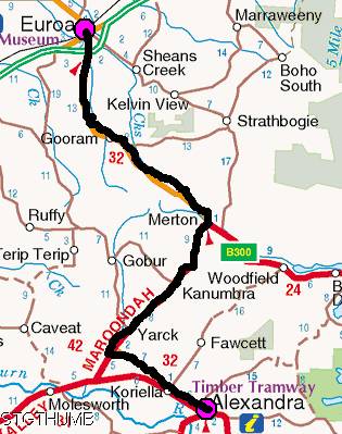
Euroa to Alexandra


Euroa to Alexandra = 65km
Cummulative total = 8392km

I thought today would never end! we woke this morning and it was beginning to rain but not too heavy so we looked at the radar and saw that it would clear by about 10am and it did - we left at 9.30am.
It was a nice gentle climb up until 19km and then it was sheer hell for me! We had looked at Bike Route Toaster before hand and they gave an average of around 6% gradient for the hill and I thought that was okay but I sought of didn't realise that they average it so parts of the hill could be 10% while other parts are 2% (hence the average is 6%!!!) so on those 10% parts I walked as you can see from the photo below!

Neil managed to ride all the hill but some of it was just too steep for me so I got off and walked the bike (which was just as hard!) although the photo above was taken near the top and although that part of the hill wasn't steep I was just sort of over it! I think it was the excess weight I was carrying in Koutas wet basket!!!
The top of the hill is at 26km and then it is a quick 3km down (but not as steep - actually I think it would have been an easier gradient for going uphill!) and then along to Merton where it was cold and windy and time for a hot cuppa.
At that point we joined the Maroondah highway and it had a wide shoulder all the way to Yarck (our turnoff).
Just out of Merton there is a gradual hill up to Burtons gap for a couple of kms and then it is a long lovely gradual down hill to Yarck. It was around 15km and would you believe this we were robbed of our down hill - we had such a strong south westerly head wind that we had to pedal down the damn down hill - I was sooooooo miffed at being robbed of a proper down hill! Neil just told me to get over it!
At Yarck we turned off to Alexandra and that was very nice and scenic


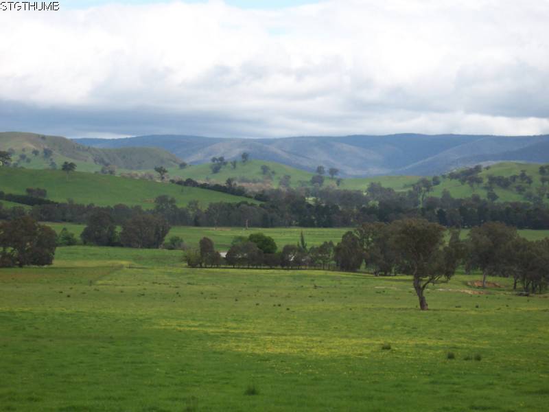
looks very hilly doesn't it!
From here this road hooks us to the Goulburn Valley Way and steadily climbs for a few kms and every now and then we keep seeing these signs about the new rail trail being constructed but it looks like they are quite a few years away from that.
Along this highway towards Alexandra there are 2 small climbs with 2 very steep descents

at the bottom of this one both Kouta and I had very watery eyes!
I was relieved to get to Alexandra it was tough today with over 700m of climbing and only 400m of ascending (of which 350m we had to pedal!) and we saw that the showgrounds was also a campground so we came here as we knew it would be cheaper than staying in a tourist campground - $15 with power since it was only a computer!
We have decided that we might not have a rest day at Eildon since the days won't be as tough or as long as today if that is the case then we should be home on Wednesday - I think Neil really wants to get home!

Friday, October 22, 2010

Shepparton to Euroa


Shepparton to Euroa = 55km
Cummulative total = 8327km

It was a warm night last night and Kouta decided that he wants to sleep right between our heads at night now and slowly throughout the night he will move down between us and eventually end up at the bottom of our feet ... if he is not too careful he will be out the door! .. yeah right as if we would do that!
We left this morning and made our way back out east towards where we came in the other day - it is very easy to get lost in Shepparton if you don't have a map as the roads around Shepparton are in a grid system but some are dead ends so if you take one of those accidently then you will have to back track! lucky we had a map with some of the street names on and we found our way to the Euroa-Shepparton road and headed south. It is flat around there so the going was good.
After you get past all the fruit trees you then come back into cattle and sheep country - so the hayfever is not to bad today - I had a good day yesterday (rest day) so that was lucky. Below is a photo of the typical country side we have been riding in.

After Moglonemby the road becomes rolling as you can see the Strathbogie ranges to your left. The road was very quiet albeit a little bumpy but most of it was a 1 lane road with light traffic.
We got to Euroa just on lunchtime and we got a powered site and for some strange reason (and this has happened to us a fair bit especially in the privately owned campgrounds) the owner was reluctant to put us in a proper powered site - first he was going to put us right next to the communal meeting area just because it was small and we would be able to fit - we said no, then he was going to put us on a corner where cars would be passing by should they come - we didn't like that, so we asked can we go along the river bank (no threat of rain tonight!) and he made up some pitiful excuse about tent pegs going into the water pipe - we didn't bother to tell him that the caravaners already there had driven their annexe pegs into the ground! So he put us in a normal site that has the hot afternoon sun but by 5.30pm we should be in shade so he says! So I am not impressed with this park - it has a lovely setting but his reluctance to put us in a spot that could be taken up by caravaners really annoyed us.
Tomorrow we go to Alexandra.

Thursday, October 21, 2010

Cobram to Shepparton


Cobram to Shepparton = 76km
Cummulative total = 8272km

Couldn't be bothered writing up the blog for yesterday last night so I am here doing it on my rest day.
It was very 'chully' yesterday morning when we got up and the tent was in the shade so we didn't really warm up at all not even when we began cycling!
Last night we went for a walk down to the Murray river and it is full and flowing

I think all rivers and creeks are full and flowing this spring!
We set off from Cobram and took the Murray Valley highway for about 11km and then we turned south on a very quiet road for Shepparton. This road has got to be the straightest road in Victoria - you could rule a line with it!
It was lovely cycling along here - flat and absolutely NO wind whatsoever! We could ride 2 abreast as there was not much traffic along here ... just paddocks of grass, milking cows and Pattersons' curse!
We did come across one field where we think it might be the local tip for scrap metal.

as you ride past it everything is in its own little piles I presume that if you wanted spare parts for something you could come along and it would be very easy to find something rather than just dumping it in one big pile - but we could see numerous bikes and 10 gallon drums!
Getting closer to Shepparton we stopped briefly at an intersection and saw this emu ...

it was very close and we thought that it might be a pet as it didn't run away from us (every other emu we have seen has bolted - have you ever seen an emu run? man they are funny looking runners!) anyway this one kept hanging around and after thinking about it we came to the conclusion that it must have had a nest nearby and that is why it didn't run - lucky for us as we got this really good close up photo of it.
We were on the outskirts of Shepparton around 12.30 and we noticed that there was alot of cyclists out riding and since it is absolutely flat out here it is an ideal town to ride around in your lunch hours. We also saw in the far distance the can of Campbells soup

not a great photo but if you look between the trees you can see an oversized can of Campbells soup - they have a factory here in Shepparton and the town also boasts having an SPC factory.
Lots of fruit trees as we rode through before the main part of town and they were in full blossom and I am going to assume they are some sort of stone fruit but they were all lined up in their rows and they were esparliered pelling?) along wires on either side of the tree - i presume so that picking the fruit is easier rather than having a mass of fruit that might be difficult to get at in the middle of the tree.
Got to the campground which is at the south end of the lake, which is currently getting an enormous make over and there are bulldozers and workmen everywhere trying to get the lake area ready by this weekend for some 150th town celebration, I don't think they are going to make it!
We are tucked in a corner with a few other tents and there is a mass of caravans together (about 80) and they all belong to some Australian motorhome and caravaning club, so Kouta can run around a bit and there is a bike/walking track just at the back of us so we can get into town easy.
Straight after lunch Neil went to Aldi and he was excited just like a kid with the fact that this was the first Aldi he has got to go in for a while ... well he was EXTREMELY excited when he got back ... because he managed to buy 2 mens cycling shorts for $17 each ... he was dancing and prancing around! not only that but he also was waving around a 2009 vintage bottle of red wine that he got for ... wait for it ... $2.49 yes!!! and he even said it was nice! so he had 1/2 last night and will finish of the rest tonight! All I requested was a packet of $3.99 melting moments ... do you reckon I got them? ... no he decided to get me a 6 pack of fruit mince tarts for $1.49 as they were better value ... the cheeky monkey!
Later on in the evening we went for a walk on one of the many bike/walking tracks and everyone was out and about on them so they definitely get used. And just at the back of us is the Goulburn river (no it is not in flood!)


It is full of water and flowing and below is a photo of the track we were on

and on this particular one we only had 1 person pass us - not sure why people weren't on this one but it was nice though.
Enjoying the rest day and will head for Euroa tomorrow and then up and over the Strathbogie (funny name!) ranges on Saturday for Alexandra.